Cliquez sur la photo pour zoomer
Prix : 15,00 €TTC
07-2025, tome 122, 2, p.203-232 Godard C., Gonnet A., Fechner K. (2025) Nogent-sur-Seine (Aube), site du Cardinal II : des fosses pré- et protohistoriques comme témoins de lévolution des sols et des paysages au cours de lHolocène
Nogent-sur-Seine (Aube), site du Cardinal II : des fosses pré- et protohistoriques comme témoins de lévolution des sols et des paysages au cours de lHolocène
Céline Godard, Adrien Gonnet, Kai Fechner avec la collaboration de Salomé Granai et Sylvie Coubray
Résumé :
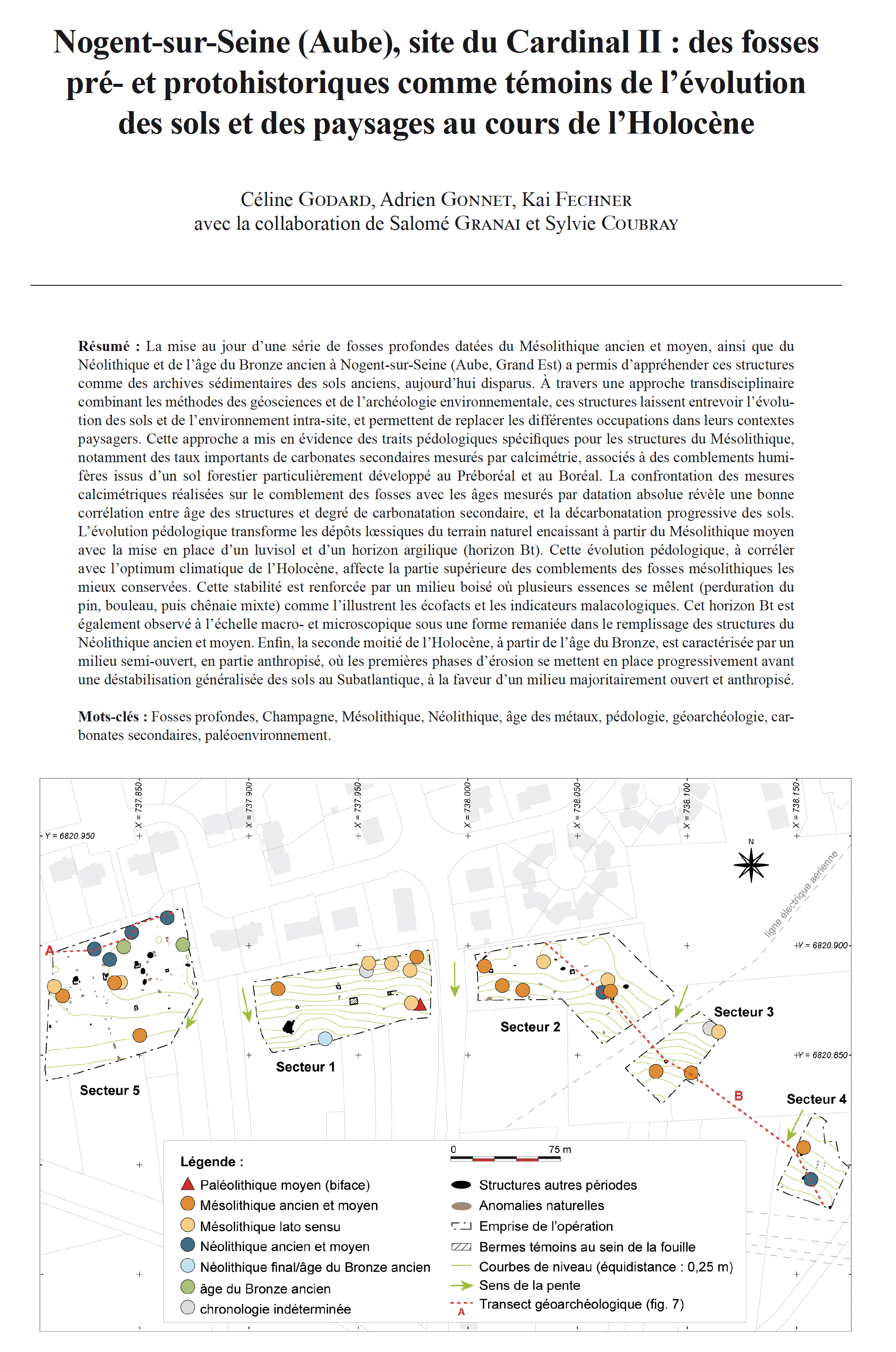
La mise au jour dune série de fosses profondes datées du Mésolithique ancien et moyen, ainsi que du Néolithique et de lâge du Bronze ancien à Nogent-sur-Seine (Aube, Grand Est) a permis dappréhender ces structures comme des archives sédimentaires des sols anciens, aujourdhui disparus. À travers une approche transdisciplinaire combinant les méthodes des géosciences et de larchéologie environnementale, ces structures laissent entrevoir lévolution des sols et de lenvironnement intra-site, et permettent de replacer les différentes occupations dans leurs contextes paysagers. Cette approche a mis en évidence des traits pédologiques spécifiques pour les structures du Mésolithique, notamment des taux importants de carbonates secondaires mesurés par calcimétrie, associés à des comblements humi-fères issus dun sol forestier particulièrement développé au Préboréal et au Boréal. La confrontation des mesures calcimétriques réalisées sur le comblement des fosses avec les âges mesurés par datation absolue révèle une bonne corrélation entre âge des structures et degré de carbonatation secondaire, et la décarbonatation progressive des sols. Lévolution pédologique transforme les dépôts lssiques du terrain naturel encaissant à partir du Mésolithique moyen avec la mise en place dun luvisol et dun horizon argilique (horizon Bt). Cette évolution pédologique, à corréler avec loptimum climatique de lHolocène, affecte la partie supérieure des comblements des fosses mésolithiques les mieux conservées. Cette stabilité est renforcée par un milieu boisé où plusieurs essences se mêlent (perduration du pin, bouleau, puis chênaie mixte) comme lillustrent les écofacts et les indicateurs malacologiques. Cet horizon Bt est également observé à léchelle macro- et microscopique sous une forme remaniée dans le remplissage des structures du Néolithique ancien et moyen. Enfin, la seconde moitié de lHolocène, à partir de lâge du Bronze, est caractérisée par un milieu semi-ouvert, en partie anthropisé, où les premières phases dérosion se mettent en place progressivement avant une déstabilisation généralisée des sols au Subatlantique, à la faveur dun milieu majoritairement ouvert et anthropisé.
Mots-clés : Fosses profondes, Champagne, Mésolithique, Néolithique, âge des métaux, pédologie, géoarchéologie, carbonates secondaires, paléoenvironnement.
Abstract:
The discovery of several deep pits dating from the Early and Middle Mesolithic as well as the Neolithic and Early Bronze Age in Nogent-sur-Seine (Aube, Grand Est, France) has made it possible to consider these structures as sedimentary archives of ancient soils, now disappeared. Indeed, since the recognition of these mesolithic pits and their inventory in Champagne at the beginning of the 2010s, these remains have been regularly unearthed on a regional scale. However, the rarity of archaeological material in their filling (a rarity that is also noted in the Neolithic and later V-Y-W shaped pits) makes it difficult to establish a consensus around their functional approach. However, beyond the question of their function, it is necessary to consider these diachronic buried structures as real sedimentary traps allowing us to understand the past environment and the evolution of soils (in the pedological sense).
Indeed, these ancient soils are largely eroded nowadays and their study through the archives that constitute these structures has a real paleoenvironmental interest. By working on the evolution of pedogenesis, as well as on the major phases of erosion and truncation of soils, it is possible to better understand the state of conservation of the remains as well as the periods of more or less intense erosion that marked the Holocene. Conversely, in order to understand the dynamics of filling an archaeological structure and its post-filling evolution (given the interrelation between the surrounding soil and the filling), it is essential to understand the morpho- and pedosedimentary evolution of the natural sequences of a site.
This issue was at the heart of the scientific prescription issued for the operation, which explicitly stipulated the contin-uous use of geoarchaeology and paleoenvironment methods. One of these methods was based on the study of recurring pedofeatures by period. Indeed, certain specific features, such as primary or secondary carbonation, are commonly observed on a regional scale in the filling of ancient pits but had never been quantified until now. However, since soil evolution is closely linked to landscape evolution, certain periods may appear more favorable to the establishment of certain pedofeatures (secondary carbonation, decarbonation). Their study and the associated landscape reconstructions make it possible to deduce the impact of natural and anthropogenic forcing in their formation.
A transdisciplinary approach was therefore implemented as part of this operation, combining methods from geo-sciences (geomorphology, pedology, micromorphology), archaeology (identification and description of fill and sur-rounding soil dynamics, radiocarbon and OSL dating) and paleoenvironments (malacology, anthracology, carpology). This approach highlighted specific pedological features for the Mesolithic structures, including significant levels of secondary carbonates measured by calcimetry. Located in a wooded environment, the Early and Middle Mesolithic structures also recorded a thick reworked humus horizon in the fill and testify to a well-developed soil during the Preboreal / Boreal, without illuviation having yet been established.
From the Middle Mesolithic, the pedological evolution transforms the loess deposits of the surrounding natural ter-rain and establishes a Luvisol and an argillic horizon (Bt horizon). This evolution, to be correlated with the climatic optimum of the Holocene, affects the upper part of the fillings of the Mesolithic pits when they are well preserved. This stability is reinforced by the wooded environment comprising diversified species (persistence of pine, birch, then mixed oak forest). The Bt horizon is also observed at the macro- and microscopic scale in a reworked form in the filling of the structures of the Early and Middle Neolithic.
Finally, the second half of the Holocene, from the Bronze Age, is characterized by a semi-open environment, partly anthropized, where erosion tends to become progressively more present before a marked destabilization of the soils in the Subatlantic, thanks to a predominantly open and anthropized environment.
This pedological transformation is corroborated by the calcimetric measurements. By quantifying in an absolute way these secondary carbonation processes within the structures and in the surrounding soil, we note a strong correlation between the degree of carbonation and the chronological period. This correlation thus underlines the impact of natural processes (climatic forcing and vegetation cover) in these secondary precipitations. The environment appears strongly decarbonated for the most recent periods of the Holocene, with the formation of the Bt horizon, which is also observed in the surrounding soil of anthropogenic structures after the Middle Mesolithic.
These conclusions on the evolution of soils remain of course dependent on the particular lithostratigraphy of the site, corresponding to Pleistocene loess deposits, pedogenized in the Holocene. They are also limited, at this stage, to a par-ticular topographical and climatic setting, on the higher slopes of the dry valleys just south of this part of the Seine val-ley. Such approaches have to be carried out in different geomorphological contexts (plateaus, foothills, valley bottoms) and in different sequences (alluvium, colluvium, chalk) in order to ensure the representativeness of this morpho- and pedosedimentary evolution pattern. In addition, this first approach should be supplemented by a precise determination of the type of secondary carbonates according to a well-defined typology. However, the regular implementation of this trans-disciplinary approach and the continuation of the study of ancient pits according to this prism could make it possible to build and feed a corpus of comparison on a regional or even extra-regional scale, based on quantified data, in order to better understand the process of pedogenesis at work in and outside archaeological structures.
Keywords: deep pits, Champagne, Mesolithic, Neolithic, metal âges, pedology, geoarchaeology, secondary carbonates, palaeo-environment.
Coordonnées
Pôle éditorial de la MSH Mondes
(Maison de l'archéologie et de l'éthnologie)
Boite 41
21 allée de l'Université
F-92023 Nanterre cedex - FRANCE