Cliquez sur la photo pour zoomer
Autres articles de " Bulletin de la Société préhistorique française 2023"
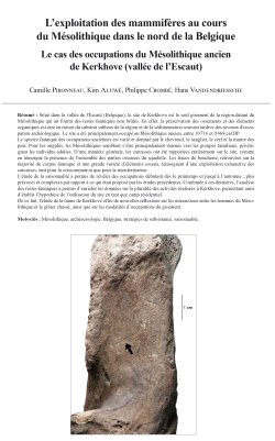
15-2023, tome 120, 4, p. 603-620 - Pironneau C., Aluwé K., Crombé Ph., Vandendriessche H. (2023) Lexploitation des mammifères au cours du Mésolithique dans le nord de la Belgique : le cas des occupations du Mésolithique ancien de Kerkhove (vallée de l
L'exploitation des mammifères au cours du Mésolithique dans le nord de la Belgique - Le cas des occupations du Mésolithique ancien de Kerkhove (vallée de l'Escaut)
Camille Pironneau, Kim Aluwé, Philippe Crombé, Hans Vandendriessche
Résumé :
Situé dans la vallée de l'Escaut (Belgique), le site de Kerkhove est le seul gisement de la région datant du Mésolithique qui ait fourni des restes fauniques non brûlés. En effet, la préservation des ossements et des éléments organiques est rare en raison du substrat sableux de la région et de la sédimentation souvent tardive des niveaux d'occupation archéologique. Le site a été principalement occupé au Mésolithique ancien, entre 10 716 et 9 469 cal BP.
Le spectre faunique des occupations anciennes est varié et dominé par le chevreuil, le sanglier, le cerf et la martre des pins. Pour les ongulés, les Mésolithiques semblent s'être principalement tournés vers les groupes familiaux, privilégiant les individus adultes. D'une manière générale, les carcasses ont été rapportées entièrement sur le site, comme en témoigne la présence de l'ensemble des parties osseuses du squelette. Les traces de boucherie, retrouvées sur la majorité du corpus faunique et une grande variété d'éléments osseux, témoignent d'une exploitation exhaustive des carcasses, tant pour la consommation que pour la transformation.L'étude de la saisonnalité a permis de révéler des occupations débutant dès le printemps et jusqu'à l'automne ; plus précoces et complexes par rapport à ce qui était proposé par les études précédentes. Combinée à ces dernières, l'analyse des restes fauniques a permis d'enrichir les données sur la pluralité des activités réalisées à Kerkhove, permettant ainsi d'établir l'hypothèse de l'utilisation du site en tant que camp résidentiel.
De ce fait, l'étude de la faune de Kerkhove offre de nouvelles réflexions sur les interactions entre les hommes du Mésolithique et le gibier chassé, ainsi que sur les modalités d'occupations du gisement.
Mots-clés : Mésolithique, archéozoologie, Belgique, stratégies de subsistance, saisonnalité.
Abstract:
The Kerkhove site, locatedin the Scheldt Valley, is the only Mesolithic site in the region that has yielded faunal remains. This situation is partly justified by the poor preservation of the organic remains. Indeed, the sandy substratum of the region and the often-late sedimentation of the archaeological occupation levels make the preservation of bones and other organic elements extremely rare. This singularity makes it possible to enrich the data on the period in the region, which is already well-documented thanks to previously published lithic and environmental studies. The site contains occupations dating from the Early Mesolithic to the Late Mesolithic. All the remains were studied, but the analysis focused mainly on the ancient occupation, which was richer in bone artifacts.
Located in the middle valley of the Scheldt, in the heart of the Flemish Ardennes, Kerkhove was the subject of preventive operations between 2015 and 2016. They focused on two sectors, the first (WP1) extending between the roof and the southern slope of the levee, and the second (WP2) being restricted to the roof of the levee. In addition to the remains scattered over the entire area of investigation, the excavations in these sectors uncovered 17 Mesolithic loci. Of these, 15 are located in the first sector, and two are in sector 2. The site's most intensive occupation occurred in the Early Mesolithic period. Based on 14C dating and technological characteristics, a minimum of nine loci can be attributed to this period. The occupations would have started between 10,716 and 10,425 cal BP and ended between 9,876 and 9,469 cal BP.
All occupations taken together, a total of 1020 pieces for the first sector and 98 pieces for the second were examined. However, in the context of this study, only the material associated with the Early Mesolithic occupations was studied exhaustively, since it contains the greatest number of remains. The taphonomic study revealed significant alteration of the remains, essentially due to weathering, limiting the reading of potential anthropic traces. Nevertheless, the identification rate remains very high thanks to the over-representation of dental remains. The fragmentation rate is also high. However, certain bone parts are found in a complete manner, such as the bones of the carpus and tarsus, the petrous bones, and the phalanges. Thus, at Kerkhove, fragmentation is high and is mainly the result of post-depositional processes.
The rich faunal spectrum is dominated by roe deer, wild boar, red deer, and pine marten. The evidence of seasonality provided by ungulates indicates that hunting episodes were spread over a large part of the year. These hunts appear to have been mainly directed towards family groups, with a preference for adult individuals within deer groups.The canine remains found at the site were the subject of DNA analysis to determine whether they were dog or wolf. This was carried out at the Wallcome Trust Palaeogenomics and Bio-Archaeology Research Network laboratory at Oxford University. Unfortunately, the conditions under which the bones were preserved did not allow the collagen to be preserved sufficiently to obtain relevant results.
The presence of all bone portions indicates that the carcasses were brought to the site in their entirety. The traces of butchery, found on most of the faunal corpus and a variety of bone elements, testify to an exhaustive exploitation of the ungulate carcasses, both for food and utilitarian purposes. Various activities have been highlighted: skin removal, emaciation (the most represented), disarticulation and dismemberment, and removal of tendons. The fracturing of bones, although not numerous, nevertheless testifies to a desire to extract the marrow. The remains of mesomammals, mainly represented by dental remains, also show traces of exploitation. The most represented activity is the removal of skins, the striations caused by which are visible mainly on the phalanges.
However, no evidence of animal hard material processing was observed, either on bones, antlers, or teeth. Observations under the microscope were made to remove doubt from certain pieces. However, the tracing studies carried out on the lithic artifacts showed that the exploitation of hard animal materials was indeed carried out on the site.The exploitation of large mammals and mesofauna for food and utilitarian purposes, as well as the results of the previous traceology analyses of the lithic artifacts, show that a multitude of activities were carried out on the site. It can therefore be stated that Kerkhove was a residential site.
From the point of view of occupation, the fauna made it possible to supplement the data already known. The study of seasonality has made it possible to highlight earlier and more complex occupations, starting in the spring. Furthermore, it would be interesting to deepen these first results with the help of cementochronological analyses and thus to specify the resolution of the ages obtained. Nevertheless, these data remain initial clues as to the possibility of occupations that were either more diversified in terms of their seasonality or longer.
Rapid analysis of the faunal spectra of the Middle Mesolithic and Late Mesolithic occupations was carried out. In both periods, ungulate remains are in the majority, but the internal classification within species changes: wild boar is the dominant species in the Middle Mesolithic, while in the Late Mesolithic, aurochs are the most represented. However, given the small number of faunal remains in the Middle Mesolithic and Late Mesolithic associated loci, it is difficult to propose comparisons and evolution between each of the assemblages. An attempt to compare species frequencies by period has nevertheless been made to propose first impressions. Thus, ungulates represent the major part of the remains during each period. The smallest mammals are only weakly represented or even absent except in the Early Mesolithic. Statistically, it is not fair to bring these comparisons and evolutions to conclusions and hypotheses. But it is interesting to have this first look at the possible variations in the faunal spectrum during the different Mesolithic periods.
The study of the Kerkhove fauna thus provides new results on the interactions of humans with other animals and introduces new perspectives on the occupation of the site.
Keywords: Mesolithic, zooarchaeology, Belgium, subsistence strategies, seasonality.
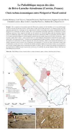
14-2023, tome 120, 4, p. 571-602 - Mathias C., Viallet C., Delvigne V., Fernandes P., Gauvrit Roux E., Lahaye C., Lebrun B., Raynal J.-P., Rué M., Tallet P. (2023) Le Paléolithique moyen des sites de Brive-Laroche-Aérodrome (Corrèze, France) : choix tec
Le Paléolithique moyen des sites de Brive-Laroche-Aérodrome (Corrèze, France) - Choix techno-économiques entre Périgord et Massif central
Cyrielle Mathias, Cyril Viallet, Vincent Delvigne, Paul Fernandes, Eugénie Gauvrit Roux, Christelle Lahaye, Brice Lebrun, Jean-Paul Raynal, Mathieu Rué, Pascal Tallet
Résumé :
Des occupations de la première partie du Pléistocène supérieur ont été identifiées sur le site archéologique de Brive-Laroche-Aérodrome (Corrèze, France) dans le cadre d'une fouille préventive. Les données livrées par cette opération permettent de s'interroger sur les comportements techno-économiques des groupes néandertaliens entre le Périgord et les contreforts du Massif central, dans un environnement géologique particulier où dominent les roches détritiques gréseuses. Deux emprises de fouille ont été explorées en contexte de plaine alluviale (nommées Nord et Sud) et les différentes nappes de vestiges indiquent une présence humaine du SIM 5 à la première moitié du SIM 4. Les données géoarchéologiques et chronologiques montrent une plus grande dispersion des indices de présence - dans le temps comme dans l'espace - pour le secteur Sud. Les corpus lithiques témoignent de l'utilisation de roches disponibles dans l'environnement local (< 10 km du site), principalement des galets de quartz. Toutefois, entre 20 % et 30 % du matériel est confectionné en silicites importées de zones plus lointaines, situées à une trentaine de kilomètres. Les chaînes opératoires mises en oeuvre sur ces matériaux sont segmentées, à l'inverse de celles concernant le quartz dont l'exploitation a eu lieu sur le site. L'économie des matières premières diffère d'un secteur à l'autre, avec une dichotomie de choix technologiques pour le traitement des quartz et silicites. Elle est le témoin de stratégies de production et de transformation influencées par la gestion des ressources et la mobilité des groupes humains dans le Sud-Ouest au Paléolithique moyen récent.
Mots-clés : Paléolithique moyen, bassin de Brive, techno-économie, quartz, silicites, Sud-Ouest de la France.
Abstract:
Southwestern France, with its numerous sites including eponymous sites, constitutes one of the richest archaeological records for the Middle Palaeolithic in Western Europe. However, data availability varies widely in this region. Techno-economic and subsistence behaviors are especially well documented in the Charente and Dordogne areas. Conversely, few data are available for the Middle Palaeolithic occupations on the fringes of the Massif central, such as in Corrèze. In this area, the mineral environment is mainly dominated by quartz, unlike the rest of the Aquitaine basin, which is rich in silicites exploited by prehistoric populations.In the Corrèze area, the Middle Palaeolithic is essentially known through surface lithic material and the past excavations of two major sites: La Chapelle-aux-Saints and Chez-Pourré Chez-Comte. Recently, preventive archaeology has allowed the discovery and excavation of open-air sites associated with the Late Middle Paleolithic (Combemenue, Brive-Laroche or les Hauts de Lestrade), offering information on the temporal framework, techno-economic behaviors of these populations, and the strategies developed in relation to the quartz pebbles and cobbles between the Périgord and the Massif central.The occupations dated to the Late Middle Palaeolithic were uncovered at the Brive-Laroche-Aerodrome site, located between the municipalities of Brive-la-Gaillarde and Saint-Pantaléon-de-Larche. Two excavation areas were explored in the alluvial plain (named North and South), which may correspond to two different sites.The geomorphological and taphonomic analysis reveals polyphase occupations, particularly in the South sector where fewer refits were identified. Only a concentration of small quartz material, which prompted manual excavation, remains unexplained in this sector. The lithic material underwent minimal mechanical alterations prior to excavation, but three levels of patina show evidence of post-depositional water circulation, and significant damage occurred during the recent mechanical excavation operation. Flood and channel deposits are present based on the stratigraphic sequence (between MIS 8 and MIS 6?). These deposits were gradually covered by poorly sorted silty deposits where the sedimentary filling of the North sector (Lb) and the base of the South sector (Lb2) are inserted. Several episodes of intense cold climate may have been responsible for the formation of a channel that truncates the archaeological horizon and the erosion of the top of Lb in the South sector. Following this cold period, colluvial formation continued in the South sector (Lsc), until the establishment of new periglacial conditions (polygonal soil, MIS 3 or 2?). The dates obtained for the archaeological levels from the infrared stimulated luminescence (IRSL) signal of the potassium feldspars in the sediment indicate an age between MIS 5 and the first half of MIS 4. It is possible to refine the chronology for the North sector between MIS 5c and 5a (94 ± 10 ka, 92 ± 10 ka, 93 ± 9 ka).The lithic assemblages demonstrate the preferential use of raw materials available in the local environment (within approximately 10 km of the site), mainly quartz pebbles and cobbles. All stages of the chaîne opératoire are represented for these raw materials, reflecting on-site knapping operations. Percussion tools (hammerstones, anvils) are also present in the lithic assemblage. In the South sector, various techniques such as Discoid (mainly unifacial), bipolar on anvil, and algorithmic debitage (SSDA.) are employed on these raw materials depending on their morphologies. The Discoid flaking concept is comparatively less common in the North sector on quartz. The reduction processes on these materials are not highly indicative of any particular techno-complex since they are found in the Lower and Middle Paleolithic without distinction in southwestern France.A significant portion of the production is derived from silicites imported from more distant areas, approximately 30 kilometers away (constituting between 20% and 30% depending on the sector). Twenty types of silicites have been identified, originating from at least six distinct geotopes. The most commonly used are the Upper Cretaceous flints (mainly Santonian) from the middle Vézère Valley, particularly the Coniacian flints found on the Montignac plateaux. The second exploited area is the Vézère-Dordogne interfluve, where blond Santonian flints are found, notably on the Tamniès plateau. The third exploited biotope is the Tourmente Valley, located to the south of the site, with Bajocian-Bathonian flints. The other geotopes are less prominent. All silicite knapping sequences are segmented, unlike those of quartz. In both sectors, a ramification (branching strategy) of the reduction processes was observed, likely in response to economic contingencies. Not only tools were transported, but also some large cortical or semi-cortical flakes to be further flaked (reserved as raw material). The modes of production are more indicative of the Middle Paleolithic, characterized by the use of Levallois and bifacial Discoid concepts of production. The identified tools on flakes predominantly consist of side and transversal scrapers, including Mousterian points.The raw material economy differs between sectors, particularly regarding tools on flakes, which are exclusively made of silicite in the North sector, while being made of both quartz and silicite in the South sector. Shaping of pebble/cobble tools and peaks is only evident in the South sector. However, in both sectors, there is a dichotomy in the technological choices between quartz and silicite, with each material reflecting specific technical preferences. In the environments of southwestern France where quartz and quartzite are most abundant, different strategies for managing raw materials were employed: identical, differentiated, or mixed. The Brive-Laroche sites exemplify differentiated quartz and silicite management, comparable to sites such as Coudoulous I, La Borde, Mas-Viel in the Lot or Bois-de-l'Hopital at Saint-Sulpice in the Tarn.This differentiated economy reflects production strategies and adapted transformations, linked to resource management and the mobility of human groups in southwestern France during the Late Middle Paleolithic.
Keywords: Middle Palaeolithic, Brive basin, techno-economy, quartz, silicites, Southwestern France.
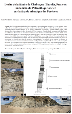
13-2023, tome 120, 4, p. 543-570 - Guibert J., Deschamps M., Colonge D., Capdevielle J., Chauchat C. (2023) Le site de la falaise de Chabiague (Biarritz, France) : un témoin du Paléolithique ancien sur la façade atlantique des Pyrénées
Le site de la falaise de Chabiague (Biarritz, France) : un témoin du Paléolithique ancien sur la façade atlantique des Pyrénées
Justin Guibert, Marianne Deschamps, David Colonge, Juliette Capdevielle, Claude Chauchat
Résumé :
Le Paléolithique ancien des Pyrénées-Atlantiques a été principalement documenté à travers quelques pièces isolées découvertes à la faveur de prospections menées sur les formations fluviales et littorales ainsi qu'à travers deux fouilles préventives récentes conduites sur les hauteurs de Bayonne. La falaise de Chabiague à Biarritz a fait l'objet de recherches diverses depuis le début des années 1970 et notamment d'une fouille de sauvetage en 1982 effectuée par C. Chauchat. Au cours de ces décennies de recherches, elle a livré un assemblage lithique composé de 510 pièces majoritairement en silex du Flysch à forte patine blanche. L'étude a porté sur cette série provenant de ramassages dans la coupe et en pied de falaise, ainsi que de l'opération archéologique de sauvetage réalisée. Un premier objectif a été de s'assurer de son homogénéité technique, puis une analyse technologique et structurale nous a permis de révéler les processus et les objectifs du système de production lithique à partir d'une grille de lecture adaptée. Les données de notre étude mettent en évidence une industrie orientée vers la production de petits outils sur éclat. A côté de ces petits outils sont associés quelques macro-outils sur plaquette et galet. Les données de cette étude replacées dans une perspective locale et étendue contribuent à questionner la singularité de l'enregistrement technique sur la façade atlantique pyrénéenne au Paléolithique ancien.
Mots-clés : Europe de l'Ouest, Pyrénées-Atlantiques, Pléistocène moyen, technologie lithique, Paléolithique ancien.
Abstract:
The Chabiague cliff in Biarritz (France) has been the subject of various investigations since the early 1970s, including a rescue excavation in 1982 by C. Chauchat. The site lies on the left bank of a small coastal creek that has carved out the valley of the same name, between Marbella beach to the north and Milady beach to the south, and faces to the Goureppe Rocks.
In this area, the coast is bordered by cliffs with an interstratification of clay and peat deposits, sands and colluvium that record part of the Quaternary. In this context, several works have studied these sedimentary records (Thibault, 1970; Ouadia, 1986; Oldfield, 1964, 1967, 1968) and have established a relative chronostratigraphy. The lithic material from the Chabiague deposit comes from unit A (layer 13) correlated by Ouadia (1986) to the Mindel-Riss interglacial, i.e., likely MIS 11 or 9 (~-310/-440 ka BP). The lithic assemblage is composed of 510 pieces, mostly Flysch flints with a deep white patina, and has been referred by C. Chauchat to an "Early Acheulean" (Chauchat, 1987). The site is no longer accessible and has been severely degraded by the urban planning of the cliff. This article presents a synthesis of the data from this assemblage and in particular an unpublished and original technological study of the lithic series.
Indeed, Lower Palaeolithic of the Atlantic Pyrenees has been mainly documented through a few isolated pieces discovered during surveys of fluvial and coastal formations. Recently, however, two preventive excavations on the heights of Bayonne city have revealed levels attributable to the Lower Palaeolithic (Colonge et al., 2015, 2017, 2018; Garon, 2013). According of all this information, it appears that given the regional scarcity of data, the Chabiague cliff series may actually offers a unique view of unequivocally Lower Palaeolithic (i.e. pre-MIS 8) industry, in the Basque region. Stills some question needs to be solved concerning the homogeneity and the representativity of the sample, conjointly with its technical characterisation.
From the whole of the lithic series, a first techno-typological seriation allowed us to identify the following categories:
1/ pieces identified as flakes (n=273)
2/ fractured pebbles (n=20) which correspond to pieces with one or more isolated removals whose anthropic nature is doubtful.
3/ fragments and debris that come from the exploitation of raw materials in the form of cobbles, pebbles or slabs (n=125).
4/ pieces identified as cores (n=35) and fragments of cores (n=14).
5/ small flake tools (n=38) which can be raw or retouched.
6/ macro tools on pebbles and slabs (n=5).
In this perspective, the application of a techno-typological (Dauvois, 1976; Tixier et al., 1980; Inizan et al., 1995) and techno-structural analyses (Boëda, 2001, 2013; Bonilauri, 2010; Bonilauri et Lourdeau, 2023) allowed us to reveal the processes and objectives of the lithic production system and to establish an appropriate reading grid of the assemblage. The data from our study show that the industry of the Chabiague cliff site is dominated by the production of small flake tools associated with few macro-tools on slabs and pebbles.
First of all, the flaking operating scheme is characterised by the exploitation of small Flysch cobbles and pebbles with a deep white patina in two main modalities: an alternating algorithmic debitage, ???S.S.D.A./Clactonian type??? (Forestier, 1993; Ashton et al., 1992), and a recurrent centripetal debitage, sometimes bipyramidal. These two debitage operating schemes have in common the search for convexities adjacent to flat surfaces in order to produce flakes and retouched tool supports.
Secondly, the shaping process, although discrete in this series, is characterised by a uni or bifacial shaping of tool matrices. The production process is concluded through the concretisation of the functional objectives of the prehistoric knappers illustrated by the following six technotypes of tools:
1/ this technotype groups together tools with lateral/transversal rectilinear cutting edge of the scraper type (n=20).
2/ this technotype is composed of flake tools with concave cutting edge (n=6).
3/ this technotype is made up of tools with lateral/transversal denticulated cutting edge (n=8).
4/ this technotype is composed of multiple tools on a flake-support (n=4)
5/ this technotype is composed of unifacial macro-tools with lateral/distal cutting edge (n=3)
6/ this technotype groups the two bifacial pieces with convex edge/tip cutting.
Finally, based on these results, the Chabiague cliff site placed in its regional context shows similarities with the Prissé and Jupiter assemblages.
Beyond this, the most important technical relationships seem to be found along the Atlantic shore with the coastal sites of Pointe de Saint-Colomban (SU 5, 6 and 7), Menez-Dregan I (SU 8 and 7b) and Pen Hat (PH4a) dated to MIS 11. In each of these deposits, the technical choices of production are directed towards SSDA knapping system of small marine flint pebbles in order to generate small rough or retouched tools. The toolkit is completed by few macro-tools present in lesser proportions.
The data from this study contribute to highlight the variability of the technical systems of the Lower Palaeolithic of the Pyrenean Atlantic coast.
Keywords: Western Europe, Pyrenées-Atlantiques, Middle Pleistocene, lithic technology, Lower Palaeolithic.
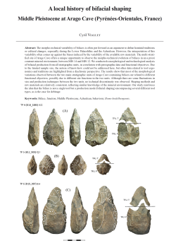
12-2023, tome 120, 4, p. 519-542 - Viallet C. (2023) A local history of bifacial shaping: Middle
Pleistocene at Arago Cave (Pyrénées-Orientales, France)
Viallet C. (2023) - A local history of bifacial shaping: Middle Pleistocene at Arago Cave (Pyrénées-Orientales, France)
Abstract:
The morpho-technical variability of bifaces is often put forward as an argument to define hominid traditions or cultural changes, especially during the Lower Palaeolithic and the Acheulean. However, the interpretation of this variability often comes up against the biases induced by the variability of the available raw materials. The multi-stratified site of Arago Cave offers a unique opportunity to observe the morpho-technical evolution of bifaces in an a priori constant mineral environment, between MIS 14 and MIS 12. We conducted a morphological and technological analysis of bifacial production from all stratigraphic units, in correlation with petrographic data and functional objectives. Due to the limited sample size, the notion of know-how could not be addressed here, but other data related to tool ergonomics and traditions are highlighted from a diachronic perspective. The results show that most of the morphological variations observed between the two main stratigraphic units of Arago Cave containing bifaces are related to different functional objectives, possibly due to different site functions in the two units. Although there are some fluctuations in size and production techniques between the two units, no technical discontinuity was observed. Shaping methods and raw materials are relatively consistent, reflecting similar knowledge of the mineral environment. Our study reinforces the idea that the biface is not a single tool but a production mode (bifacial shaping) encompassing several different tool types, as is the case for debitage.
Keywords: Biface, function, Middle Pleistocene, Acheulean, behaviour, Homo heidelbergensis.
Résumé :
Malgré plusieurs tentatives pour ne plus considérer un seul type d'outils au Paléolithique inférieur, les bifaces constituent toujours le fondement des réflexions sur l'évolution comportementale et les migrations humaines au Pléistocène inférieur et moyen. Cet intérêt particulier peut s'expliquer car il s'agit des seuls outils pour lesquels les analystes pensent percevoir une norme et peuvent, de fait, envisager d'interpréter les variations de chaînes opératoires. Présents en Afrique et en Eurasie depuis 1,7 Ma, les bifaces permettent en effet de documenter une large fenêtre de l'histoire technique humaine. Mais cette amplitude spatio-temporelle, a pour revers une variabilité des contextes - notamment géologique, anthropologique et taphonomique - rendant le plus souvent caduques les tentatives de globalisation. Parallèlement, un retour épistémologique sur les bifaces, documente l'accrétion de paradigmes - en particulier leur perception comme monolithe fonctionnel - qui tendent à scléroser les discussions.
En effet, les bifaces sont le plus souvent associés à un seul type d'outil, un couteau à tout faire mais surtout destiné à des activités de boucherie. Pourtant, ce n'est pas le résultat des analyses fonctionnelles, malgré leur faiblesse numérique liée à la conservation médiocre des traces d'usages. Ainsi, si l'association avec des activités de boucherie existe, les résultats issus de la revue bibliographique illustrent des usages en découpe, en raclage et en percussion lancée. Des bifaces sont également utilisés pour le travail du bois en raclage, pour la découpe de racines ou encore en percussion lancée dans le sol ou sur du bois. La diversité des gestes effectués et des matériaux travaillés - associée à la variabilité probable des systèmes socio-économiques dans lesquels les bifaces s'insèrent - conditionne la définition d'outils différents.
Devant l'impossibilité de donner du sens à la variabilité des bifaces à l'échelle globale, nous proposons d'étudier l'évolution des bifaces dans un contexte géographique similaire et sur un temps relativement court (à l'échelle de deux stades glaciaires successifs), permettant d'atténuer l'impact des facteurs environnementaux.
Ce cadre analytique est offert par le site de la Caune de l'Arago (Pyrénées-Orientales, France), disposant de plusieurs niveaux d'occupations contenant des bifaces datés du Pléistocène moyen. Site en grotte à l'extrémité sud de la France, la Caune de l'Arago s'ouvre à l'aplomb du Verdouble, au sein d'une vallée sous la forme d'une anse, propice aux activités cynégétiques. Le remplissage de la cavité est subdivisé en plusieurs complexes stratigraphiques, dans lesquels d'autres subdivisions permettent de raisonner à l'échelle d'unités archéo-stratigraphiques (UA). L'analyse porte ici sur les UA contenues dans les trois ensembles du complexe moyen, pour lesquels les données sédimentologiques, paléontologiques et radiométriques, permettent une corrélation avec les MIS 14, 13 et 12. Les bifaces sont présents dans les UA des ensembles I et III, corrélés respectivement aux phases glaciaires des stades 14 et 12. Le site offre donc la possibilité d'analyser localement l'évolution des bifaces, dans des conditions environnementales (climat et ressources lithologiques) a priori semblables. En excluant les pièces pour lesquelles l'état de conservation ne permet pas une attribution certaine à cette catégorie, la Caune de l'Arago livre 64 bifaces : 39 dans l'ensemble I et 25 dans l'ensemble III, dont 28 aptes à une analyse technico-fonctionnelle.
Partant du constat que la production de bifaces répond à des objectifs fonctionnels variés et que les analyses tracéologiques se heurtent à la reproductibilité des résultats en l'absence de récurrences liées à la conservation insuffisante des artefacts, la diversité fonctionnelle est abordée grâce à une analyse technico-fonctionnelle. Elle intervient en supplément des analyses pétrographiques et technologiques et permet de caractériser différents types d'outils au sein d'un même mode de production. L'outil, considéré en tant que système, est composé d'une unité active, d'une unité de préhension et d'une zone de transmission de l'énergie. L'association de l'unité active et préhensive crée un couple fonctionnel caractérisant la structuration de l'outil. L'unité active peut présenter différentes conformations qui, une fois individualisées, permettent de créer des techno-types. Ils correspondent au regroupement d'outils présentant potentiellement un même schème de fonctionnement.
Les résultats permettent de mettre en évidence treize techno-types différents, dominés par des couples fonctionnels (partie active et préhensive) structurés par une opposition transversale ou oblique. Les conformations dominantes de la partie active sont pointues et convexe en plan. Les techno-types sont diversement représentés à l'échelle des unités archéo-stratigraphiques et des ensembles stratigraphiques, montrant une variété des objectifs fonctionnel. Les matières premières sont pareillement diversifiées dans les deux ensembles, montrant une continuité dans les connaissances de l'environnement minéral. A l'exception de l'utilisation de la percussion tendre dans l'ensemble I, les méthodes et les techniques de production ne varient pas sensiblement en diachronie.
La mise en relation de l'évolution de ces objectifs fonctionnels avec les variations des paramètres environnementaux est inopérante. En effet, les ensembles I et III de la Caune de l'Arago s'insèrent dans des périodes glaciaires, avec un spectre faunique relativement similaire. Plus globalement, il semble que les temporalités de l'évolution climatique et de l'évolution technologique ne s'expriment pas dans les mêmes espace-temps, ne permettant pas de percevoir l'influence de la première sur la seconde, au moins pour le Pléistocène moyen. La présence d'une phase de réchauffement intercalée, correspondant à l'ensemble II de la Caune de l'Arago, permet d'observer l'absence de bifaces mais pas de leurs déchets de fabrication et donc d'envisager une relation entre la fonction du site et la diversité des objectifs de la production bifaciale. L'hypothèse d'un lien entre la durée d'occupation et les objectifs fonctionnels remplis par les bifaces peut être émise, mais ne peut être démontrée sur la base unique des données de la Caune de l'Arago.
Pour conclure, la diversité des objectifs fonctionnels perçus parmi les bifaces de l'Arago s'avère l'expression multiple d'un même mode de production qu'est le façonnage bifacial. L'idée d'un outil invariant et polyfonctionnel n'est pas soutenue par les séries de la Caune de l'Arago. La variabilité des résultats technologiques et fonctionnels en Afrique et en Eurasie, l'intégration - ou non - des ces outils dans des cycles d'existences longs ou encore la variété des choix pétrographiques, montre bien toute la diversité des outillages obtenus par façonnage bifacial. Il est donc temps d'analyser la variabilité fonctionnelle au sein de ce système productif et de la confronter ensuite aux choix de matières premières et aux savoir-faire afin de discuter l'évolution cognitive et comportementale humaine au cours du Paléolithique inférieur.
Mots-clés : Biface, fonction, Pléistocène moyen, Acheuléen, comportement, Homo heidelbergensis.

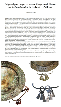
11-2023, tome 120, 3, p.419-454 - Eluère C. (2023) Énigmatiques coupes en bronze à large marli décoré, ou Breitrandschalen, de Hallstatt et d'ailleurs
Énigmatiques coupes en bronze à large marli décoré, ou Breitrandschalen, de Hallstatt et d'ailleurs
Christiane Eluère
Résumé :
Datées du Ha C jusqu'au début du Ha D, une soixantaine de coupes en bronze à large marli ont été recensées de la Pologne à l'Alsace, avec une densité particulière dans la nécropole de Hallstatt (Haute-Autriche). Des études synthétiques précédentes ont permis de définir deux grands groupes avec, entre autres, une prédominance du décor ornithomorphe dans l'aire septentrionale, du décor géométrique, dans l'aire sud-orientale. Ces coupes dont le diamètre peut atteindre 45 cm et le marli 7,5 cm de largeur représentent toutefois une catégorie de vaisselle particulière dont on a du mal à comprendre la place et l'usage.
A partir d'une révision détaillée du corpus de Hallstatt, une attention spéciale est portée ici sur la syntaxe des marlis décorés et les techniques d'exécution. Les coupes sont d'abord cataloguées par type de motif principal : figuratif ornithomorphe (anatidés à tête en pointe, à tête à crinière, à tête à houppe) ou non-figuratif géométrique (cercles estampés, bossettes embouties, points repoussés) ou sans décor apparent. De rares exemples d'autres supports dotés de motifs ornithomorphes semblables sont rassemblés (tableau 1) pour comparaison. La finition des bords externes permet plus particulièrement d'dentifier des habitudes d'atelier, des centres de production (tableau 2), et d'essayer d'évaluer les influences extérieures qui entrent en jeu. Une production propre à Hallstatt est identifiée, toutefois certaines coupes à décor ornithomorphe trahissent des contacts avec des régions avoisinant l'Erzgebirge (Pologne, Tchéquie, Sud-Est de l'Allemagne), possible source d'étain, et les coupes à décor géométrique, un peu plus récentes, reflètent des influences du Sud-Est, des productions du Sulmtal ou de zones plus éloignées comme la Slovaquie et la Hongrie. Les principaux éléments des contextes passés en revue (tableau 3) montrent entre autres qu'à Hallstatt, les coupes à décor ornithomorphe seraient plutôt l'apanage des hommes.
A l'aide de données issues de recherches récentes sur divers autres sites dans la zone hallstattienne orientale ou dans les centres contemporains au sud des Alpes, l'enquête s'élargit vers le problème de l'usage de ces coupes, de leur contenu potentiel, de leur place dans le rituel funéraire. La diversité de leur morphologie, de leur construction et de leur décor, mise en évidence ici, conduit à supposer des utilisations diversifiées dans le monde des vivants, variables selon les régions. Le décor estampé d'anatidés associés à des soleils semble être lié à une évocation de l'au-delà, encore proche du mythe de la barque solaire, et l'hypothèse d'un usage de brûle-parfum est abordée notamment pour les coupes munies d'une gorge circulaire et montées sur pied.
Peu à peu se dessine une approche plus fine grâce à l'observation des décors de ces grandes coupes en bronze à large marli, production prestigieuse d'assez courte durée pour quelques personnages ayant un rôle social particulier dans ces groupes du nord des Alpes.
Mots-clés : Hallstatt, vaisselle de bronze, décor ornithomorphe, premier âge du Fer.
Abstract:
Between the Ha C and the beginning of Ha D (VIIIth-early VIIth century B.C.) around 60 bronze bowls with a decorated broad rim (Breitrandschalen) have been buried in rich tombs between Poland and Alsace, with a particular concentration in the Hallstatt cemetery (Upper Austria). Precedent studies have shown that towards the North of their distribution area these bowls often have a foot and are decorated with stamped aquatic birds while towards the South-East their decoration is geometric and they have a flat bottom. In Hallstatt both groups are represented throughout ca 30 cups, the half of the total corpus. Although they are finds from old excavations, it seems interesting to study them as a starting point of an investigation about this particular type of vessels, which significance is still unknown. The aim of the article is also to draw the attention on the important role of the decoration which is inseparable part of an item.
The first part is devoted to a catalogue of the pieces from Hallstatt, classified by decoration type of the rim, starting with the main pattern : 1°) figurative, stamped aquatic birds (head with a vertical point, head with a mane, head with a tuft, three-dimensional birds) ; 2°) geometric (stamped circles, embossed bumps, repoussé points, dots, and bowls without apparent decoration). Comparisons with similar vessels outside Hallstatt or similar decoration patterns on other objects are listed, particularly regarding those with aquatic birds (table 1). It is important to consider the whole syntax of the decoration : i.e. in the middle of the rim, besides the principal pattern, the accompanying patterns (circles, bumps, suns),
as well as the finishing of the edges, the « grip » type (attached ring, riveted handles), the bottom, with or without a foot (table 2). The situation in the tombs, the context, are shortly recorded too (table 3).
The second part of the article is dedicated to some comments on comparative pieces among contemporary vessels in neighboring regions. Some other broad rim types, with embossed or stamped decoration, in Northern Italy, illustrate a new common tendency in bronze smithing techniques. Among the technical observations, the problem of the alloy is raised. Unfortunately very few bowls have been analyzed, only two exemplaries from recent excavations in Domas?aw (Poland) made in a bronze with a high tin content (15 %). In any case these bowls reaching sometimes a diameter of 45 cm and an average rim width of 5 cm, but which can reach up to 7,5 cm, most likely represented a technical challenge for the bronzesmiths and some repairs of the sheets are often observed. The setting of the foot is a special technique adoperated on the Hallstatt pieces while on other cups from south Germany it is usually riveted or embedded. The finishing of the external edge of the rims reveals characteristic features of the workshop in which they were made. In that way a production « made in Hallstatt » has been determined (table 2). External influences are also likely, with probable connections to regions around the Erzgebirge, and later with the Sulmtal, as well as Slovakia and Hungary.
A circular groove along the internal border of the rim might be an important feature meaning that it maybe was designed to support a lid or a filter. The grip type gives clues on different possibilities of use. Bowls with two riveted large horizontal handles are suitable for being carried with both hands for bringing offerings, while those with an attached ring and foot were maybe made to be exhibited on an altar or a table. The decoration with aquatic birds, maybe inspired from the myth of the Solar Barge spread during the Final Bronze Age, draws special attention. The systematic orientation of the aquatic birds (ducks, gooses, swans ?) is probably significant as shown through some comparisons with Etruscan frescoes of early VIIth century B.C. and their role is probably, more or less related with afterlife or a cosmogonic research.
Some new finds in the Eastern Hallstatt area or in southern Alp, their location and the context in the tombs give rise to interesting hypothesis : we may imagine that these bronze cups were protected in wooden boxes, baskets of textile wrappings or placed inside wooden set of shelves. Their place in the cremation tombs in Hallstatt is often central, above the ashes or nearby. Analyzing the context types, it seems that bowls decorated with aquatic birds are more frequent in male tombs while the female tombs often contain bowls with geometric pattern. This might correspond with a slightly later stage and new rites (table 3).
Finally, the possible content of the bowls is discussed, and the hypothesis of incense or perfume burners is put forward for the items with foot, circular groove and decoration with aquatic birds.
When buried in tombs most of the objects, especially the vessels, loose the identity they had during their life-time. These broad-rim bowls, due to their diversity in morphology and decoration, their local specificities - here underlined - should be considered not as a whole but as a complex range of different precious ritual vessels, anyway works of art, part of the « sets » of the elites in the Northern Alps during this period of the Early Iron Age.
Keywords: Hallstatt, bronze vessel, aquatic birds, Ealy Iron Age.
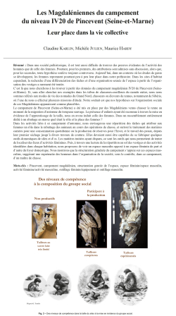
10-2023, tome 120, 3, p.385-418 - Karlin C., Julien M., Hardy M. (2023) Les Magdaléniennes du campement du niveau IV20 de Pincevent (Seine-et-Marne) : leur place dans la vie collective
Les Magdaléniennes du campement du niveau IV20 de Pincevent (Seine-et-Marne)
Leur place dans la vie collective
Claudine Karlin, Michèle Julien, Maurice Hardy
Résumé :
Dans une société préhistorique, il est tout aussi difficile de trouver des preuves évidentes de l'activité des hommes que de celle des femmes. Pourtant, pour les premiers, des attributions sont admises sans discussion, alors que, pour les secondes, toute hypothèse soulève toujours controverse. Aujourd'hui, dans un contexte où les études de genre se développent, les femmes reprennent pourtant peu à peu leur place dans notre préhistoire. Dans les sites d'habitat cependant, la recherche d'une différenciation des tâches et d'une organisation sexuée de l'espace à partir de l'organisation des vestiges a rarement été tentée.
C'est là que nous cherchons à les trouver à partir des données du campement magdalénien IV20 de Pincevent (Seine-et-Marne). Et, sans aller chercher nos exemples dans les tribus de chasseurs-cueilleurs du monde entier, nous nous sommes référés aux modes de vie des nomades du Grand Nord, chasseurs ou éleveurs de rennes, notamment de Sibérie, où l'une de nous a effectué plusieurs missions d'étude. Notre souhait est que nos hypothèses sur l'organisation sociale de ces Magdaléniens apparaissent comme plausibles.
Le campement de Pincevent (Seine-et-Marne) a été mis en place par des Magdaléniens venus chasser le renne au moment de la migration d'automne du troupeau sauvage. La présence d'enfants ayant été reconnue à travers la mise en évidence de l'apprentissage de la taille, nous en avons induit celle des femmes. Dans un rassemblement entièrement dédié à un abattage en masse quel était le rôle et la place des femmes ?
Dans les activités liées à ce campement d'automne, nous envisageons une répartition des tâches qui attribue aux femmes un rôle dans le rabattage des animaux au cours des opérations de chasse, et surtout le traitement des matières carnées pour une consommation quotidienne ou la production de réserves pour l'hiver, et le travail des peaux, depuis leur premier séchage jusqu'à divers travaux de couture. Elles devaient aussi être capables de se fabriquer quelques outils domestiques de silex et d'os. Les matières traitées ayant disparu, ce sont les outils qui nous permettent de tenter de localiser des lieux d'activités féminines. Puis, à travers une lecture de la répartition au sol des vestiges et des activités identifiées dans chaque habitation, nous proposons de voir un espace masculin opposé à un espace féminin de part et d'autre du foyer domestique. Nous montrons que la structuration générale du campement s'appuie sur ces espaces masculins, suggérant une suprématie des hommes dans l'organisation de la société, sous le contrôle, dans ce campement, d'un maître de chasse.
Mots-clés : Pincevent, campement magdalénien, structuration genrée de l'espace, espace féminin/espace masculin, activité féminine/activité masculine, outillage féminin/équipement et outillage masculin.
Abstract:
In a prehistoric society, it is just as difficult to find clear evidence of male activity as it is of female activity. However, for the former, attributions are admitted without discussion, whereas, for the latter, any hypothesis always raises controversy. Today, in a context where gender studies are developing, women are nevertheless gradually resuming their place in our prehistory. Yet, in settlement sites, the search for a differentiation of tasks and a gendered organization of space based on the distribution of remains has rarely been attempted.
This is what we wanted to do using the data of the IV20 Magdalenian camp at Pincevent (Seine-et-Marne), excavated on over 5,000 m2. And, without looking for examples in the tribes of hunter-gatherers around the world, we referred to the lifestyles of the nomads of the Far North, hunters or herders of reindeer, particularly in Siberia, where one of us carried out several study expeditions. Our wish is that our hypotheses on the social organization of these Magdalenians appear plausible.This camp was occupied during several weeks in the autumn, 13,000 years ago by Magdalenian hunters during the migration of reindeers towards their winter territories. The distribution of the remains shows varying densities concentrations.
The four most significant have been interpreted as dwellings, while in the periphery numerous less dense concentrations have been considered as more or less occasional workshops. The purpose of this study is to identify the place of women in their daily life.
In the 1980s, an analysis of the skills implemented in flint knapping made it possible to document the existence of varying levels of know-how. Among the productive knappers who supplied the group with flint tools, we distinguished experienced knappers capable of carrying out the project they had designed and competent knappers who did not always know how to master the vagaries of the raw material but nevertheless participated in the production of domestic tools. Non-productive knappers with a low level of know-how were also identified: in our view, they are young Magdalenians in training. The presence of children thus recognized by the learning of knapping leads us to conclude that women were present. As a result, we have sought to recognize the role of these women according to the nature of the toolkit and the productions, and with the help of ethnographic surveys among nomadic populations of reindeer herders-hunters in Siberia. All activities contribute to the smooth running of collective life and allow the group to live together. Our interest is to imagine, from our data, who was doing what. Starting from the principle that any society is built on a sharing of tasks, we ask ourselves what part fell to women. A reindeer slaughter camp during the autumn passage of the wild herd, we wonder about their role in the hunt, knowing that we make ours the postulate of an exclusion of bloods, which kept them away from the actual slaughter. We believe, however, that they could participate in the great hunts by driving the game towards the hunters. But it was also possible for them to hunt according to their own rules: young reindeer juveniles of the year probably caught by hand and trapped hares. The large quantity of game
slaughtered at this camp supposes an organized chain of animal material processing. Reindeer antlers seem to have been assigned to male activities. Bones may have provided tools for both men and women. We propose that the processing of the rest -meat material, tendons and hides- was essentially a concern of female activities, because they were linked
to the domestic world. In this moment of abundance of burdens for women, it is possible that men have collaborated, for example, in operations related to the treatment of bones.
In our view, the experienced knappers are the men making their own weapons, in particular because they produce the backed bladelets that will arm the spear shafts. As it is difficult to imagine a total dependence of women to obtain the flint tools they needed, we assume that simply competent knappers could be of either sex. In addition, a large number of unprocessed but used pebbles were identified at the camp. If some of these tools on pebbles could have been used by men, the majority would correspond to specifically female toolkits involved in various domestic work around edible matters or in the treatment of hides. The mass of materials to be processed would explain the abundance of these tools.
Because it structures society, this distribution of tasks is coupled with a gendered organization of space that assigns everyone a specific place, both within the dwelling and in the layout of the camp. By observing the organization of the remains in the dwellings, we propose that the living space was structured into two parts in relation to the domestic hearth. This partition would reflect the status of each and everyone in the social organization of the unit. Considering
the hearth as the center of the domestic unit, it seems to us that it is really determined by the location of the permanent knapping workstation. This is truly the most striking element of the male area. Facing it, on the other side of the hearth, the female area is linked to its setting up and to the maintenance of the fire. This area is marked by small workstations dedicated to the working of animal materials and, in particular, to boning, cutting up muscles and extracting marrow.
Our hypothesis is that these two spaces, male and female, were protected by easily movable hide carpets, which is suggested by emptier areas lined with accumulations of remains.
It also appears that a significant proportion of male activities took place in the peripheral workshops. Only two workshops can be attributed with some certainty to specifically female activities: both seem to have been places for hide working, one at a distance from the dwellings, no doubt to dry them and, without doubt, to carry out the first steps of the cleaning, the other to treat them in a posterior technical stage. There are a large number of used pebbles and, in the sediment of the small associated hearth, the concentrated remains of reindeer fat.
The organization of the dwelling cannot be dissociated from that of the camp. The alignment of the settlements in Pincevent was a function of the topography of the place, but also of rules specific to the group. These must have determined the setting up of each dwelling, in relation to each other, according to the social status of the occupants. Finally,
the orientation of each dwelling could obeyed climate or cosmogonic considerations, but also very clearly social constraints. It is the axis of the male workstations located near the domestic hearths that seems to structure the organization of the camp and that of this small group of hunters. Indeed, one can think that the "hunting master", whose dwelling was oriented in the opposite direction to the others, chose his place first to have an overview of the camp. His setting up, the easternmost, west-facing, allowed him to see the different social units of his group, which were facing east. All of these rules therefore determined, for women, the setting up of the hearth and the location of each dwelling, as well as the location of female working areas in relation to those of men.
At the end of this study, it appears that Magdalenian society, during this period of hunting, was governed by male power. We cannot say what it was like in other places, during other seasons.
Keywords: Pincevent, Magdalenian camp, gendered spatial structuration, female space/male space, female activity/ male activity, female toolkit/male equipment and toolkit.
09-2023, tome 120, 3, p.361-383 - Guillermin P. (2023) ?€? Mas Aguilhon, un nouveau jalon pour la connaissance du Gravettien dans le Sud-Est de la France
Mas Aguilhon, un nouveau jalon pour la connaissance du Gravettien dans le Sud-Est de la France
Patricia Guillermin
Résumé :
Le site de Mas Aguilhon est situé sur la rive droite de la moyenne vallée du Rhône, en Sud Ardèche. La série lithique, issue de prospections mais aussi de sondages, est restée quasiment inédite (Combier, 1967 ; Gilles, 1994). L'ensemble comprend 80 outils retouchés et 560 produits de débitage. Parmi les outils, les armatures correspondent à des pointes à cran, des micropointes de la Gravette, des lamelles à dos parfois tronquées ou bitronquées ainsi qu'à des lamelles retouchées. Le reste de l'outillage est en majorité composé de grattoirs peu allongés, de burins diversifiés parmi lesquels plusieurs burins de Noailles, de lames tronquées, d'une lame appointée et de pièces esquillées.
La production de lamelles et de petites lames semble être réalisée sur place selon un schéma opératoire unipolaire à cintre polyédrique et base convergente.
Bien qu'il n'existe pas de référentiel régional permettant une caractérisation chrono-culturelle précise et que la question de l'homogénéité de l'assemblage reste posée, le site de Mas Aguilhon peut être attribué, au moins pour une grande partie, à un technocomplexe gravettien à burins de Noailles. Une vision synthétique des occupations considérées comme gravettiennes dans la région a été proposée (Onoratini et al., 1999 ; Onoratini et Combier, 1999). Les sites datés sont principalement les sites ornés, à commencer par la grotte Chauvet-Pont d'Arc dont la deuxième phase d'occupation relève de la période du Gravettien moyen (Quilès et al., 2016, Delannoy et Geneste, 2020). A plus large échelle, la chronologie des ensembles à burins de Noailles reste à préciser selon les régions, notamment dans le Sud-Est de la France. L'association présumée de burins de Noailles, de pointes à cran - dont une pointe à cran à dos adjacent - et de lamelles à dos tronquées oriente l'attribution chrono-culturelle de l'ensemble lithique de Mas Aguilhon vers la période du Gravettien moyen, voire moyen-récent, c'est-à-dire entre 32 000 et 27 300 cal BP si l'on tient compte de l'ampleur chronologique du phénomène des pointes à cran à plus vaste échelle (Banks et al., 2019 ; Simonet, 2014).
Mots-clés : Gravettien, Ardèche, plein air, industrie lithique, technologie lithique, pointes à cran, burins de Noailles, grotte Chauvet-Pont d'Arc.
Abstract:
The site of Mas Aguilhon is located in the middle Rhône Valley in the southern Ardèche region. It was discovered in 1963 by R. Gilles, an amateur prehistorian in Saint-Marcel-d'Ardèche. The lithic assemblage, recovered during a survey and test excavation, has remained largely unpublished (Combier, 1967; Gilles, 1994). In this article, I present my recent typo-technological study of this assemblage.
The lithic assemblage comprises 80 tools and 560 flaking by-products. Among the tools, the weapon elements include shouldered points, Gravettian micro-points, backed bladelets, sometimes truncated or bi-truncated, and retouched bladelets. The rest of the toolkit comprises a majority of relatively short end-scrapers, diverse burins, including Noailles burins, truncated blades, one pointed blade, and bipolar flakes (pièce esquillée).
The main objective of the bladelet debitage was to produce blanks for backed bladelets, microgravettes and retouched bladelets. This production is partly continuous with that of the small blades used as blanks for shouldered points, Noailles burins and truncated blades. Some pieces are twisted and have tapered, sometimes asymmetrical distal ends, associating a straight edge and convergent skewed edge. On the small blades, this convergent skewed distal end sometimes corresponds to a semi-abrupt side (Type A). Other bladelets and small blades are more regular, sometimes thick and do not converge distally (Type B). The last type consists of thinner, wider and irregular small blades with a distal convergence and no abrupt side (Type C). These types are not associated with any particular tools. Rather, they served as blanks for the different weapon element types, as well as for all types of domestic tools.
Most of the small blades were made via a convergent unidirectional flaking scheme and have an oblique intersection plane at their proximal end, favoring an oblique abrupt or semi-abrupt convergent side at the distal end. The horizontal plane of the flaking surface is polyhedral, associating a curved surface with a flatter one. Thicker bladelets and small blades were detached from the curved surface, while thinner, wider and often more irregular pieces were detached from the flat surface. The striking platform is plain, with varying obliquities relative to the flaking surface, one transverse, the other lateral at the flanks, favoring off-axis detachments that result in a torsion of the blanks and/or a distal convergence.
This scheme enabled the production of three blank types that may have been advantageous for the production of small Type A blades. There's a modality with two striking platforms that enabled the production of the three blank types but favored thicker and straighter Type B blanks due to its more curved volume.
Another modality, with a facial exploitation of the volume, also produced the three blank types but favored thinner and wider Type C products detached from the frontal surface of the volume. Another more modality also produced occasional bladelets, many with an abrupt side.
The objective of this scheme was to obtain weapon element blanks, consisting of the most regular blades, and domestic tool blanks, corresponding to the small blades, some of which are regular, or technical pieces, resulting from the repair of overshot flakes or pieces from the side of the core, for example.
A second scheme corresponds to the detachment of small rectilinear, tapered bladelets from the sharp edge of a flake. These bladelets have no abrupt side and their length ranges from 10 to 25 mm. These pieces are absent from the assemblage.
While the Mas Aguilhon site can be attributed to a Gravettian technocomplex with Noailles burins, the region lacks a regional reference base that would enable a more precise chrono-cultural attribution. In the Ardèche, there is no stratigraphy that sufficiently documents the Early Upper Paleolithic, nor the Gravettian in particular, for which no chronological facies have been described.
A broad perspective of the occupations considered as Gravettian has nonetheless been proposed (Onoratini et al., 1999; Onoratini & Combier, 1999). Noailles burins are sometimes present in the assemblages of cave sites in the Ardèche gorges, such as Le Marronier, Le Figuier, La Grotte aux Points and Baou-de-la-Sello (Onoratini et al., 1999; Madelain, 1976; Monney, 2018; Gilles, 1994), as well as Chassezac, and the Abris des Pêcheurs (Lhomme, 1976 and 1977). The sites that have been dated are mainly decorated ones, beginning with the Chauvet-Pont d'Arc Cave, whose second occupation phase has been attributed to the Middle Gravettian (Quilès et al. 2016, Delannoy & Geneste, 2020). On a broader scale, despite the recent summaries of dates obtained at Gravettian sites in southwestern France (Banks et al., 2019; Douka et al., 2020), the chronology of assemblages with Noailles burins still needs to be refined in some regions, such as southeastern France. At Mas Aguilhon, the presumed association of Noailles burins, shouldered points, including one with an adjacent back, and truncated backed bladelets recalls the assemblages of sites such as Brassempouy (Simonet, 2012) and Level G of the Grotte des Enfants (Balzi Rossi, Ligurie, Italy) (Onoratini, 1978; Simonet, 2010).
This association orients the chrono-cultural attribution of the Mas Aguilhon lithic assemblage toward the Middle or Middle-Late Gravettian, extending to 23,000 BP if we consider the shouldered point phenomenon at a larger scale, integrating the central and eastern European assemblages (Simonet, 2014).
Keywords: Gravettian, Ardèche, open-air, lithic industry, lithic technology, shouldered point, Noailles burin, Chauvet-Pont d'Arc Cave.
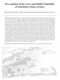
08-2023, tome 120, 3, p.311-359 - Koehler H., Moine O., Affolter J., Diemer S., Wuscher P. (2023) - Re-evaluation of the Lower and Middle Palaeolithic of Achenheim (Alsace, France)
Re-evaluation of the Lower and Middle Palaeolithic of Achenheim (Alsace, France)
Héloïse Koehler, Olivier Moine, Jehanne Affolter, Simon Diemer, Patrice Wuscher
Abstract:
During their exploitation, the quarries of Achenheim and Hangenbieten (Alsace, France) provided access to an exceptional loess-paleosol sequence, totalling over 40 m in thickness and spanning at least four glacial-interglacial cycles. As early as 1914, E. Schumacher identified thirty stratigraphic units, in which, over the course of almost a century, numerous large faunal remains and lithic artefacts scattered within various levels would be revealed, although only two of these levels were extensively excavated. In particular, the site offers an almost complete key sequence to understand early settlement dynamics in the Rhine valley and particularly the transition between Lower and Middle Palaeolithic, at the boundary between western and central Europe. Nevertheless, data are old and artefacts were recovered by quarry workers and repositioned after their collection. Moreover, while many chronostratigraphic and paleoenvironmental studies have been made during the last decade, the data are dispersed and rarely combined. Due to these biases Achenheim's archaeological data could be disregarded. In the present study, we aim to take a fresh look at the reliability of Achenheim's lithic assemblages. We focus on Lower and Middle Palaeolithic lithic remains, re-examined here in detail. In parallel, their chronostratigraphic position in terms of marine isotope stages, as well as the contemporaneous palaeoenvironmental characteristics, have been checked by combining all available data scattered in many publications concerning older quarries that are no longer accessible or difficult to access. By comparing the archaeological data from this site with the most recent discoveries, both in Alsace and elsewhere in north-western and central Europe, we can show that the lithic industries, though largely incomplete, represent an interesting sample which sheds new light on the succession of lithic technocomplexes of early settlement in the Upper Rhine area. The various technical manifestations identified at Achenheim seem to match the overall techno-typological sequence observed for the Middle and Late Pleistocene of either northwestern or central Europe.
Keywords: Lower Palaeolithic; Middle Palaeolithic; Lithic industries; Loess; Palaeoenvironment; Upper Rhine.
Résumé :
Au cours de leur exploitation, les carrières d'Achenheim et d'Hangenbieten (Alsace, France) ont permis l'accès à une séquence de loess exceptionnelle, totalisant plus de 40 m d'épaisseur et couvrant au moins quatre cycles glaciaires-interglaciaires. Dès 1914, E. Schumacher identifie une trentaine d'unités stratigraphiques, au sein desquelles, pendant près d'un siècle, seront mis au jour de nombreux restes archéologiques, tant fauniques que lithiques. L'importance de cette séquence a suscité l'intérêt de nombreux chercheurs, français, belges, suisses et allemands qui ont mené plusieurs études pluridisciplinaires, notamment environnementales et stratigraphiques durant plusieurs décennies de la fin du xxe siècle. Néanmoins, il ne résulte de ces études publiées tantôt en français, tantôt en allemand, tantôt en anglais, aucune synthèse exhaustive ni aucun schéma détaillé excepté une vision synthétique des cycles glaciaire-interglaciaire. Il est ainsi difficile d'avoir une lecture globale de la stratigraphie.
De plus, les objets archéologiques ont fait l'objet d'études assez anciennes et méritent d'être réexaminés à l'aune des connaissances actuelles, d'autant plus que leur mode de collecte est éloigné des standards modernes. En effet, excepté deux niveaux ayant fait l'objet de fouilles approfondies, le reste de la collection a été collecté au gré de l'exploitation des carrières, le plus souvent par les ouvriers, mais néanmoins avec un suivi stratigraphique permettant de positionner les objets au sein des ensembles sédimentaires. Il convient ainsi de s'interroger sur la fiabilité de cet ensemble archéologique, afin de savoir quelles informations peuvent en être raisonnablement exploitées. La première question porte sur la validité du positionnement des objets aux bons ensembles sédimentaires. La seconde sur la corrélation des ensembles sédimentaires à une chronostratigraphie précise, permettant alors de les comparer ensuite à d'autres ensembles bien calés des régions voisines. Ces questions sont d'autant plus importantes que le site d'Achenheim se situe dans une région globalement pauvre en sites paléolithiques. Cette lacune archéologique observée dans tout le Rhin supérieur limite toute étude de la dynamique de peuplement à l'échelle européenne.
Dans cet article, nous nous concentrons sur les vestiges lithiques du Paléolithique inférieur et moyen, qui ont fait l'objet d'un réexamen détaillé. Une étude technologique et pétrographique a notamment été réalisée sur les objets de la collection Wernert, représentant un corpus de 860 objets inégalement répartis au sein de plus de 21 unités sédimentaires.
Toutes les mentions stratigraphiques rattachées aux objets archéologiques ont été réexaminées et il s'avère que la plupart des objets sont bien attribués à une unité sédimentaire précise. En parallèle, le positionnement chronostratigraphique de ces ensembles sédimentaires a été soigneusement questionné, en combinant toutes les données disponibles dispersées dans la littérature concernant les carrières les plus anciennes qui ne sont plus accessibles. Les caractéristiques paléoenvironnementales ont ainsi été scrupuleusement vérifiées en les comparant notamment aux données disponibles au sein de séquences plus récentes. Suite à ce travail, il a été possible de confirmer ou proposer des rattachements de la plupart
des unités sédimentaires à des stades isotopiques marins et ainsi repositionner les ensembles archéologiques dans un cadre chronostratigraphique global, facilitant leur confrontation aux autres sites disponibles de part et d'autre du Rhin.
Le croisement des données archéologiques de ce site avec les découvertes les plus récentes, tant en Alsace qu'ailleurs dans le nord-ouest et le centre de l'Europe, permet de démontrer que l'industrie lithique, quoique largement incomplète, peut être considérée comme un échantillon cohérent pour porter un regard nouveau sur la succession des cultures lithiques des premiers peuplements dans la région du Rhin supérieur. Les diverses manifestations techniques identifiées à Achenheim semblent s'inscrire dans l'évolution techno-typologique globale observée pour le Pléistocène moyen et supérieur, tantôt d'Europe du Nord-Ouest, tantôt d'Europe centrale.
Mots-clés : Paléolithique inférieur, Paléolithique moyen, industries lithiques, loess, paléoenvironnement, Rhin supérieur.
07-2023, tome 120, 2, p. 219-251 - Mougne C., Dupont C. (2023) Marine invertebrates during the Bronze Age and the Iron Age on the French Channel-Atlantic seashore: state of the art and first synthesis
Marine invertebrates during the Bronze Age and the Iron Age on the French Channel-Atlantic seashore: state of the art and first synthesis
Caroline Mougne, Catherine Dupont
Abstract: The exploitation of marine invertebrates (molluscs, crustaceans, and echinoderms) on the French Channel-Atlantic coast is a poorly known topic in archaeology for the Bronze Age and the Iron Age (2300/2200 to 25 BC). The primary aim of our work is to assess whether this lacuna is due to the absence of data or rather to a bias related to researchers??? lack of interest in this type of archaeological remains. We have drawn up an inventory of all the 240 archaeological sites (including both islands, coastal-continental and inland-continental sites) where marine invertebrates were identified. Archaeomalacological studies were available for 41 sites, 39 of which were studied by the authors of this paper. Firstly, the unprecedented discovery of some species led to new methodological developments. Secondly, the results enable us to broach a variety of issues, such as the types of exploited environments, the subsistence economy (diet, geographical specificities, exchange networks), artisanal activities (dyeing, personal ornaments, construction materials), as well as funerary and ritual practices (deposits, ritual meals). Combined with other archaeological data, the study of marine invertebrates thus contributes, in an unprecedented way, to a better understanding of the socio-economic and cultural systems of coastal and continental communities during this period.
Keywords: archaeomalacology, shell, Bronze Age, Iron Age, Atlantic French coast, economy, ritual, ornament.
Résumé : Cet article propose une synthèse de l'exploitation des invertébrés marins (mollusques, crustacés et échinodermes) le long du littoral Manche-Atlantique de la France à la période protohistorique (2300/ 2200 à 25 av. J.-C.). Il intègre de nombreuses études qui se sont multipliées depuis 2010 sous l'impulsion d'une thèse dédiée à cette thématique.
Un des premiers objectifs de la synthèse proposée est de dresser un inventaire de tous les sites archéologiques qui ont livré des invertébrés marins, à savoir un total de 240 sites. Parmi eux, 41 ont fait l'objet d'une étude archéomalacologique marine, dont 39 ont été effectuées par les auteures de cet article. Les résultats obtenus permettent d'aborder la question de l'exploitation des milieux et des pratiques alimentaires, artisanales, architecturales, funéraires et cultuelles des populations protohistoriques concernées.
Ainsi, quelle que soit la zone du littoral abordée, les environnements côtiers exploités dans l'Ouest de la France durant l(âge du Bronze et l'âge du Fer sont essentiellement les milieux rocheux. Ce type de substrat a pu être choisi du fait d'une plus grande accessibilité des espèces qui y vivent, dans la mesure où ces dernières peuvent être repérées directement à la surface du rocher. L'exploitation du milieu sableux semble, quant à elle, fortement liée à des contextes funéraires et cultuels et à des utilisations singulières (parure et offrandes). La totalité des espèces consommées présentes sur les sites était collectée en zone intertidale, c'est-à-dire, à pied sec. L'environnement proche d'un site et les invertébrés marins disponibles localement ont probablement joué un rôle important dans les choix des espèces consommées, indiquant la pratique d'une collecte à pied réalisée dans les environs immédiats de l'habitat. Toutefois, le spectre des espèces découvertes sur les sites archéologiques révèle généralement une collecte sélective qui suggère des choix culturels parmi les espèces disponibles.
De fait, l'étude des pratiques alimentaires permet de souligner de façon inédite des spécificités régionales. Ainsi, les actuelles régions de la Normandie, de la Bretagne et de l'Aquitaine se caractérisent par des assemblages malacologiques et un mode de sélection distincts. En Bretagne, la patelle Patella sp. est omniprésente, tandis qu'elle est totalement absente de l'alimentation des habitants de la Normandie. Ces derniers consomment essentiellement des moules communes Mytilus edulis. Pour ce qui est de l'Aquitaine, les spectres malacofauniques varient selon les sites, même pour ceux de période identique. Il est à noter que les populations protohistoriques de cette région ne semblent pas s'être focalisées sur le ramassage d???une seule espèce, à l'inverse des régions plus septentrionales.
D'un point de vue diachronique, en Normandie et en Bretagne, les espèces sélectionnées sont les mêmes pendant l'âge du Bronze et l'âge du Fer. Ces régions se différencient de l'Aquitaine, où une évolution des pratiques alimentaires entre le Bronze ancien et La Tène finale est clairement perceptible. En effet, si pendant l'ensemble de la Protohistoire la patelle, la moule commune et la scrobiculaire Scrobicularia plana sont consommées, l'huître plate Ostrea edulis et la palourde européenne Ruditapes decussatus intègrent le régime alimentaire des populations à partir de la fin de l'âge du Fer. L'inclusion de l'huître plate, voire de la palourde, en tant que composants majeurs des régimes alimentaires des populations côtières, pourrait résulter d'une influence romaine. Cette dernière est d'ailleurs connue sur d'autres produits marins, comme les poissons par exemple. La consommation de l'huître plate augmente par la suite, à savoir, au début de l'époque gallo-romaine.
A cette époque, une évolution des pratiques alimentaires se produit en Normandie et en Aquitaine. Des coquillages marins frais sont importés dans l'arrière-pays pour y être consommés, et ce, jusqu'à 120 km du littoral. La consommation des coquillages dans les terres pouvait, à en juger par leur rareté, être réservée à quelques individus ou groupes sociaux d'un rang élevé. Des réseaux d'échanges, voire un commerce de mollusques et plus largement de produits marins, existaient probablement pour approvisionner ces sites de l'hinterland.
Outre leur place dans l'alimentation, les invertébrés marins ont également joué un rôle dans plusieurs activités artisanales durant la Protohistoire :
- l'utilisation du pourpre dans des activités tinctoriales est attestée uniquement en Bretagne, et ce, au moins dès l'âge du Fer voire dès l'âge du Bronze, ce qui est, dans les deux cas, une attestation inédite pour l'Ouest de la Gaule. En effet, cette activité n'était connue jusqu'à présent sur tout le territoire français qu'après la conquête romaine ;
- pour la parure, au moins quatre espèces de coquilles ont servi de matière première, à savoir le cyprée Trivia monacha, la littorine obtuse Littorina obtusata, le dentale Antalis sp. et la coque Cerastoderma sp. Les collections étudiées se caractérisent par leur hétérogénéité, aussi bien d'un point de vue géographique, chronologique, contextuel que morphologique. Une différenciation marquée entre les espèces réservées à la parure et celles destinées à la consommation est observée pendant la Protohistoire, constat déjà réalisé pour la Préhistoire le long des côtes atlantiques françaises. Il semblerait qu'à l'âge du Bronze la coquille utilisée pour la confection de parure soit progressivement remplacée par les métaux. Ces matériaux sont plus résistants et permettant de créer des formes plus complexes ;
- les restes d'invertébrés marins et particulièrement les coquilles de mollusques sont parfois utilisés comme matériaux de construction. Sur la façade atlantique française, un tel recyclage de coquilles est connu dans la construction des murs ainsi que pour assainir les sols. Ce recyclage concerne deux taxons consommés en grande quantité, à savoir la patelle et l'huître plate. La réutilisation de ces deux espèces est due à leurs propriétés physico-chimiques : leurs coquilles résistent aux pressions mécaniques, drainent les flux d'eau et sont perméables, absorbant l'humidité ambiante, souvent importante en milieu côtier et insulaire. L'utilisation des coquilles dans les constructions est proportionnellement liée à l'importance de leur consommation.
Les invertébrés marins jouaient également un rôle non négligeable au sein des systèmes de pensée et de croyances des populations protohistoriques. Ils sont ainsi parfois repérés sous forme de dépôts votifs, d'offrandes alimentaires ou encore de restes de repas rituels ou communautaires. Ils ont été déposés, voire mis en scène, dans au moins trois secteurs le long de la façade française de la Manche et de l'Atlantique : en Plaine de Caen, sur les côtes bretonnes et charentaises. Les espèces d'invertébrés marins intervenant dans les pratiques funéraires et cultuelles varient. Il s'agit le plus souvent de taxons consommés de manière régulière et faisant partie du régime alimentaire, comme la patelle en Bretagne ou la moule en Plaine de Caen. Les coquillages de la famille des Cardiidés (coque Cerastoderma sp. et bucarde Acanthocardia sp.) semblent être également sélectionnés pour des événements particuliers liés aux pratiques cultuelles en Plaine de Caen. Chaque contexte se caractérise par un assemblage spécifique, que ce soit au niveau des espèces choisies ou des objets associés. Ces pratiques sont difficilement généralisables du fait la rareté de leur découverte et de la diversité des objets et coquilles associées. Elles témoignent de pratiques variées qui pourraient correspondre des manières de faire et de penser distinctes.
Cette synthèse sur les restes coquilliers marins de la Protohistoire n'en est qu'à ses débuts. Les données obtenues sont prometteuses et innovantes. Les résultats soulignent les implications de ces animaux marins dans de nombreux domaines de la vie des communautés de l'âge du Bronze et de l'âge du Fer et permettent d'aborder des thématiques inédites.
Mots-clés : archéomalacologie, coquillage, âge du Bronze, âge du Fer, Atlantique, France, pratiques alimentaires, rituel, parure.
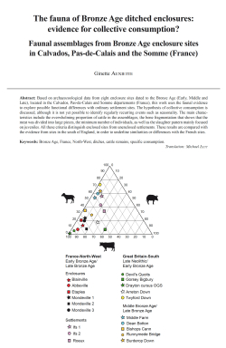
06-2023, tome 120, 2, p. 207-218 - Auxiette G. (2023) The fauna of Bronze Age ditched enclosures: evidence for collective consumption? Faunal assemblages from Bronze Age enclosure sites in Calvados, Pas-de-Calais and the Somme (France)
The fauna of Bronze Age ditched enclosures: evidence for collective consumption?
Faunal assemblages from Bronze Age enclosure sites in Calvados, Pas-de-Calais and the Somme (France)
Ginette Auxiette
Abstract: Based on archaeozoological data from eight enclosure sites dated to the Bronze Age (Early, Middle and Late), located in the Calvados, Pas-de-Calais and Somme départements (France), this work uses the faunal evidence to explore possible functional differences with ordinary settlement sites. The hypothesis of collective consumption is discussed, although it is not yet possible to identify regularly recurring events such as seasonality. The main characteristics include the overwhelming proportion of cattle in the assemblages, the bone fragmentation that shows that the meat was divided into large pieces, the minimum number of individuals, as well as the slaughter pattern mainly focused on juveniles. All these criteria distinguish enclosed sites from unenclosed settlements. These results are compared with the evidence from sites in the south of England, in order to underline similarities or differences with the French sites.
Keywords: Bronze Age, France, North-West, ditches, cattle remains, specific consumption.
Translation: Michael Ilett
Résumé : ?€ partir des études archéozoologiques de huit sites à enclos datés de l'âge du Bronze (Bronze ancien, moyen, final) situés dans les départements du Calvados, du Pas-de-Calais et de la Somme (France), cet article s'attache à confronter les données de corpus fauniques, afin de proposer une attribution fonctionnelle différente de celle de simples enclos d'habitat. L'hypothèse de consommations collectives est posée, sans qu'il soit encore possible de proposer une scansion des évènements (saisonnalité). Les principales caractéristiques réunissent plusieurs critères parmi lesquels la composition des assemblages, avec notamment l'écrasante part du boeuf, la conservation des os qui permet d'évaluer un traitement des pièces de viande en gros morceaux car les os sont peu fragmentés, le nombre minimum d'individus et les âges d'abattage relativement concentrés sur des animaux juvéniles. Tous ces critères distinguent ces sites à enclos des sites d'habitat non enclos. Ces résultats ont par ailleurs été confrontés à ceux issus de plusieurs sites britanniques situés au sud de l'Angleterre, afin de proposer des ressemblances ou des dissemblances avec les sites français.
Mots-clés : Âge du Bronze, France, Nord-Ouest, fossés, restes de bétail, consommation spécifique.
Resumen : A partir de los estudios arqueozoológicos de ocho sitios con recintos datados en la Edad del Bronce (Bronce antiquo, medio y final) ubicados en los departamentos de Calvados, Pas-de-Calais y Somme (Francia), este artículo trata de comparar los datos del corpus faunístico, con il fin de proponer una atribución funcional diferente a la de simples recintos de hábitat. Se plantea la hipótesis del consumo colectivo, sin que sea posible proponer una escansión de los acontecimientos (estacionalidád). Las principales características reúnen varios criterios, entre los cuales la composición de los conjuntos, en particular la abrumadora proporción de carne de res, la conservación de los huesos, que permite evaluar el tratamiento de las piezas de carne en trozos grandes porque los huesos están poco fragmentados, el número mínimo de individuos y las edades de matanza relativamente concentradas en los animales jóvenes. Todos estos criterios distinguen estos sitios cerrados de los sitios de hábitat no cerrados. Además, estos resultados se compararon con los de varios sitios británicos ubicados en el sur de Inglaterra, con el fin de proponer similitudes o disimilitudes con los sitios franceses.
Palabras clave: Edad del Bronce, Francia, Noroeste, acequias, restos de ganado, consumo específico.
Traducción : Léna Girard
Zusammenfassung: Dieser Artikel befasst sich mit acht früh-, mittel- und spätbronzezeitlichen Einfriedungen in den französischen Departements Calvados, Pas-de-Calais und Somme. Er konfrontiert deren Faunadaten miteinander, um eine andere funktionale Zuordnung vorzuschlagen als die einfacher Siedlungseinfriedungen. Die Hypothese von kollektiven Mahlzeiten wird vorgelegt, ohne dass es zurzeit möglich wäre, diese saisonal näher einzuordnen. Zu den signifikantesten Kriterien gehören die Komposition der Inventare, bei denen Rinderknochen bei weitem den höchsten Anteil ausmachen, zudem die Erhaltung der Knochen, die erkennen lässt, dass das Fleisch in großen Stücken abgetrennt wurde, denn die Knochen sind kaum fragmentiert, schließlich die Mindestindividuenzahl und die relative Konzentration des Schlachtalters auf Jungtiere. Alle diese Kriterien unterscheiden diese Einfriedungen von den nicht umfriedeten Siedlungsplätzen. Die Ergebnisse wurden darüber hinaus mit denen mehrerer Fundplätze im Süden Englands konfrontiert, um Ähnlichkeiten oder Unterschiede mit den französischen Fundplätzen aufzuzeigen.
Schlüsselwörter: Bronzezeit, Frankreich, Nordwesten, Gräben, Viehreste, spezifischer Verbrauch.
Übersetzung : Isa Odenhardt
05-2023, tome 120, 2, p. 161-206 - Bizot B., Barthès P., Bosansky C., Cenzon-Salvayre C., Lardeaux J.-M., Reggio A., Schmitt A., Thirault E. (2023) Gargas,Beyssan (Vaucluse), précisions sur le contexte funéraire associé aux stèles gravées du Néolithique
Gargas, Beyssan (Vaucluse), précisions sur le contexte funéraire associé aux stèles gravées du Néolithique moyen
Bruno Bizot, Pascale Barthès, Christiane Bosansky, Carine Cenzon-Salvayre, Jean-Marc Lardeaux, Adrien Reggio, Aurore Schmitt, Éric Thirault, avec la collaboration de Didier Binder, Michel Dubar, Gilles Durrenmath et Sabine Sorin-Mazouni
Résumé : La découverte en 2013 lors de labours d'un ensemble remarquable de mobilier du Néolithique moyen ainsi que de deux stèles gravées a donné lieu à deux articles publiés dans le Bulletin de la Société préhistorique française (Bosansky et D'Anna, 2015 et D'Anna et al., 2015). Une fouille de sauvetage entreprise en 2014 a permis de mieux préciser le contexte de ce mobilier et de compléter le corpus.
L'essentiel des vestiges occupe une petite dépression proche d'un ruisseau et est réuni dans deux petits locus bordés chacun d'un alignement de pierres en aval. Le mobilier, abondant, a subi les atteintes du feu et se rapporte à des dépôts secondaires de crémations caractérisés par des esquilles d'os dont une partie au moins sont humains. Malgré les dégradations dues aux labours, une étude spatiale permet de restituer la position et l'étendue des principaux dépôts secondaires. Deux d'entre eux, dans le locus nord, mieux conservés, sont bien dotés en matériel : billes, lames de haches, céramiques et armatures trapézoïdales. Dans le locus sud, un dépôt de restes humains crématisés a été réalisé entre deux blocs placés dans une petite fosse. Les lames de hache ont été disposées au sommet des dépôts.
La majorité du mobilier archéologique a été chauffé. Les billes et lames de hache témoignent de façonnages de grande qualité et, pour les dernières, les matières premières allochtones sont les plus représentées. La céramique est quant à elle dominée par des vases de facture soignée destinés pour la plupart au service : assiette, coupes, jattes et gobelets.
Le mobilier ainsi que les sept datations par le radiocarbone réalisées placent ces dépôts secondaires dans les deux premiers siècles du IVe millénaire. Les modalités de dépôt des restes prélevés sur les bûchers sont comparables à celles restituées pour les sites provençaux de la deuxième moitié du Ve millénaire des Bagnoles (Van Willigen et al. dir., 2020) et Sainte-Musse (Gourlin dir., 2016) témoignant ainsi d'une perduration de pratiques mortuaires de modalités similaires. Le site de Beyssan se distingue cependant par l'abondance d???un mobilier choisi et, pour les lames de haches au moins, de grande qualité ayant été peu ou pas utilisé avant leur dépôt dans le bûcher. En l'absence d'autres vestiges à proximité immédiate, les stèles gravées découvertes en 2013 sont probablement à associer à ces sépultures.
Mots-clés : Néolithique moyen, Provence, dépôt secondaire de crémation, lames de hache, billes, pétrographie, céramique, industrie lithique, datations radiométriques.
Abstract: This rescue archaeological excavation carried out in 2014 aimed to precise the context associated with two stelae published in 2015 (Bosansky and D'Anna, 2015 and D'Anna et al., 2015). A series of test pits enabled to delimit the site measuring around forty square metres. It appears isolated from the large areas that had yielded Neolithic material in the same geographical area.
The remains are spread out into two locus. Each of them is bordered by an alignment of stones and includes concentrations of blocks, burnt bones and objects: sherds, flint industry, balls and axe blades.
The ceramic material found by collecting or excavation constitutes a homogeneous assemblage. It consists of 582 sherds relating to plates, small spherical cups with simple profiles, carinated bowls or an open concave neck, as well as two beakers. A few gripping elements or suspensions ??? appliques, perforated lug, ribbon or boudin handles and tubulures ??? are also present. One sherd is decorated with an incised grid.
The lithic industry counts 278 pieces. Most of the flints have been affected by high heat. The only raw material identified is Barremo-Bedoulian flint. In 17% of the cases, it was deliberately heat treated. The supports are mainly blades with trapezoidal cross-sections; they are raw or retouched into scrapers or geometric bitroncatures. The knapping waste and two nuclei indicate that boasting may have taken place on site. The lithic batch includes a small nucleus made of hyaline quartz (?).
Thirty-four balls were collected from the excavation or from the surface. This is a particularly high number compared to regional examples. Their large diameter and very low sphericity index indicate a high quality production. 31 of these balls were made in carbonate rocks, 2 in sandstone rocks and 1 in tenaceous green rock. One third of them are altered by heat.
A total of 30 polished axe blades were discovered in this small site. They represent an important concentration of objects for the Vaucluse. All of the polished blades and fragments relate to achieved pieces, possibly repaired. Twenty-nine of them come, with varying degrees of probability, from the Monviso or Beigua massif. These tools are longer than the regional average and, in 9 out of 17 cases, the cutting edges are in perfect condition or only slightly blunted; they are (almost) new or have been resharpened. At least 6 of these blades had been exposed to high heat.
Twenty-six batches of burnt bones were collected during the excavation. Most of them were fragments measuring no more than 1 cm, as well as numerous splinters. The attribution to human remains could be certified for some bone fragments and one monoradiculated tooth. The human bone fragments belong to long bone diaphyses, ribs and some cranial remains. The white colour of the bones indicates cremation at a high temperature (600-800°C). Infants are not represented. One of the deposits in the southern locus was placed in a small pit.
The 166 anthraco-remains analysed consisted solely of deciduous oak (Quercus f.c.). Seven of them were radiocarbon dated. The dates obtained are consistent with the nature of the material. The occupation falls within a range limited to the first three centuries of the 4th millennium. The treatment of the dates in a Bayesian matrix (Oxcal 4.2) places the beginning of this occupation between 4010 and 3800 cal BC (at 95.4%) and the end between 3950 and 3740 cal BC. The duration is statistically estimated at 150 years.
The elements gathered during this excavation leave little doubt as to the funerary function of this small site, away from the residential contexts identified in the Beyssan area. The remains are concentrated in two well-characterised locus bordered by alignments of stones that may relate to small terrace walls close to a stream bed. The association of burnt human bones and artefact, the small quantities of ashes and the absence of any trace of rubefaction in the excavated area, as in the 2900 m² of the surrounding area that was explored by test pits, suggest that the two locus gathered secon-dary cremation deposits that took place in two restricted spaces that were partially structured by the low walls and perhaps some stone blockwork. The distribution in plan of the best characterised objects shows concentrations, particularly in the northern locus where three sets gather the majority of the beads (8/11) and axe blades (7/8) discovered during excavation. The southern locus presents a well-preserved deposit between two blocks placed in a shallow pit. It combines burnt human bones, a bowl, a nucleus, a geometric bitroncature and sherds. Four other concentrations of bones and objects from the southern locus could belong to deposits dismantled by ploughing. In all cases observed, the axe blades were placed on top of the deposits.
Whatever the mode of treatment of the corpse, burial or cremation, mortuary sites from the end of the 5th millennium or the beginning of the 4th millennium are rare in southern France. Two sites in Provence, dated to the second half of the 5th millennium, are particularly well documented: Toulon Sainte-Musse (8 structures, 4350-4250 cal BC; Gourlin et al., 2014), l'Isle-sur-la Sorgue les Bagnoles (8 structures, 4360-4000 cal BC, Van Willigen et al., 2020). They share many particularities with Beyssan: comparable levels of fragmentation and weight of bones, variable quantities of objects of individual or domestic equipment, mostly altered by fire, and a few objects, the most voluminous or remar-kable, which appear to have been deposited separately.
Comparisons across southern France show that the objects are more abundant in burials involving cremation and that axe blades are exclusively associated with it. These examples testify a codified funerary practice that lasted several centuries. However, the Beyssan site stands out for its exceptional quantity and quality of archaeological material. The most significant elements are the almost exclusively north-italic raw material used to make the majority of the axe blades and their low wear, the abundance of bowls, their perfect execution, as well as ceramic material essentially destined for service. These characteristics, as well as the presence of stelae, refer to the ancient discoveries of Trets la Bastidonne (Escalon de Fonton et al., 1955; Escalon de Fonton, 1961, 1962; D'Anna and Mills, 1981; Binder, 1991; D'Anna et al., 2015; Masson-Mourey et al., 2020), which fall within the same chronological range as Beyssan.
Keywords: Middle Neolithic, Provence, secondary cremation deposit, axe blades, balls, petrography, ceramics, lithic industry, radiometric dating.
04-2023, tome 120, 2, p. 135-160 - Lucas C., Cook J., Pétillon J.-M., McGrath K., Van der Sluis L. Cartwright C., Ladier E., Grubert M. (2023) Industry and art on osseous materials from Courbet cave (Penne, Tarn, France) in the British Museum coll.
Industry and art on osseous materials from Courbet cave (Penne, Tarn, France) in the British Museum collections: evidence of Magdalenian connections
Claire Lucas, Jill Cook, Jean-Marc Pétillon, Krista McGrath, Laura Van der Sluis, Caroline Cartwright, Edmée Ladier, Morgane Grubert
Abstract: The Magdalenian site of Courbet cave in the Aveyron valley is renowned for a significant contribution to the nineteenth century debate about human antiquity and an outstanding set of engraved and sculpted artworks. The typological content of the assemblage nevertheless remained poorly known, making it difficult to assess the place of Courbet cave within Magdalenian settlements of south-western France. This paper presents a review of over 1 300 pieces of osseous industry recovered during the main excavation led by the Vicomte de Lastic in 1863-64 and now curated at the British Museum. The assemblage composition corroborates the attribution of most of the collection to an Upper Magdalenian characterised by the prevalence of double bevel base points primarily decorated on the lateral faces, numerous barbed implements, and half-round rods decorated with a new variety of engravings. An earlier component includes single bevel base points and typical artworks documented in Middle Magdalenian layers at other sites. Locally, the osseous assemblage from Courbet cave bears a strong resemblance to that from Fontalès and there is abundant evidence of contacts beyond the Aveyron valley. While some representations are indicative of close connections to the Pyrenean and North Aquitaine areas, the actual movement of some objects over long distances is confirmed by the unexpected identification of two artefacts made of whale bone imported from the Atlantic coast. This finding clearly shows the Magdalenian inhabitants of the Aveyron valley were part of wider networks.
Keywords: Aveyron valley, osseous industry, portable art, whale bone, circulation network.
Résumé : Le site magdalénien de la grotte du Courbet, dans la vallée de l'Aveyron, est bien connu pour sa contribution au débat du xixe siècle sur l'antiquité de l'Homme et son extraordinaire série d'oeuvres gravées et sculptées. La composition typologique des assemblages lithiques et osseux est néanmoins restée peu connue, ne facilitant pas l'évaluation de la place de la grotte du Courbet parmi les gisements magdaléniens du sud-ouest de la France. Cet article présente une série de plus de 1 300 pièces d'industrie osseuse exhumées lors de la principale fouille du site, menée par le Vicomte de Lastic en 1863-64, et aujourd'hui conservées au British Museum. Le reclassement et l'enregistrement de cette collection ont permis de préciser la composition typologique de la série et d'identifier des pièces remarquables, parmi lesquelles figurent deux objets en os de baleine et 27 pièces d'art mobilier inédites. Ces nouvelles données apportent de plus amples informations pour l'attribution chrono-culturelle du Magdalénien de la grotte du Courbet et la compréhension de ses relations avec les zones environnantes.
La composition de l'industrie osseuse confirme l'attribution de la plus grande partie de la série à un Magdalénien supérieur caractérisé par la prédominance des pointes à biseau double essentiellement décorées sur les faces latérales, de nombreux éléments barbelés (pointes barbelées et foënes), et des baguettes demi-rondes présentant une nouvelle variété de décors. La diversification de la thématique figurative se traduit par une présence non négligeable d'espèces auparavant rares (poissons, saïgas, représentations difficilement identifiables), de gravures de pointes barbelées et d'un motif végétal. Les décors géométriques typiques du Magdalénien supérieur comprennent de courts arcs de cercles « en coup d'ongle », des petits reliefs ovalaires, des rainures crantées et un motif tressé. Une occupation à la charnière du Magdalénien moyen et supérieur est suggérée par la présence d'une pointe à base fourchue. Par ailleurs, une composante plus ancienne inclut quelques pointes à biseau simple et des types d'oeuvres gravées et sculptées documentés dans des niveaux du Magdalénien moyen d'autres gisements, en particulier des crochets de propulseurs sculptés en forme de tête de cheval et des baguettes demi-rondes à parenthèses et trèfles.
Localement, l'industrie osseuse de la grotte du Courbet ressemble largement à celle de Fontalès par sa composition générale et certains caractères rares, tels qu'une quantité relativement importante de foënes ou la présence de pièces à épaulement. La collection du Courbet présente aussi de nombreux indices de contacts au-delà de la vallée de l'Aveyron. Alors que certaines gravures suggèrent des liens étroits avec les zones pyrénéenne et nord-aquitaine, le déplacement d'objets sur de longues distances est confirmé par l'identification inattendue de deux objets en os de baleine importés de la côte atlantique. Ces nouvelles données démontrent que les habitants magdaléniens de la vallée de l'Aveyron faisaient partie de réseaux largement étendus.
Mots-clés : vallée de l'Aveyron, industrie osseuse, art mobilier, os de baleine, réseau de circulation.
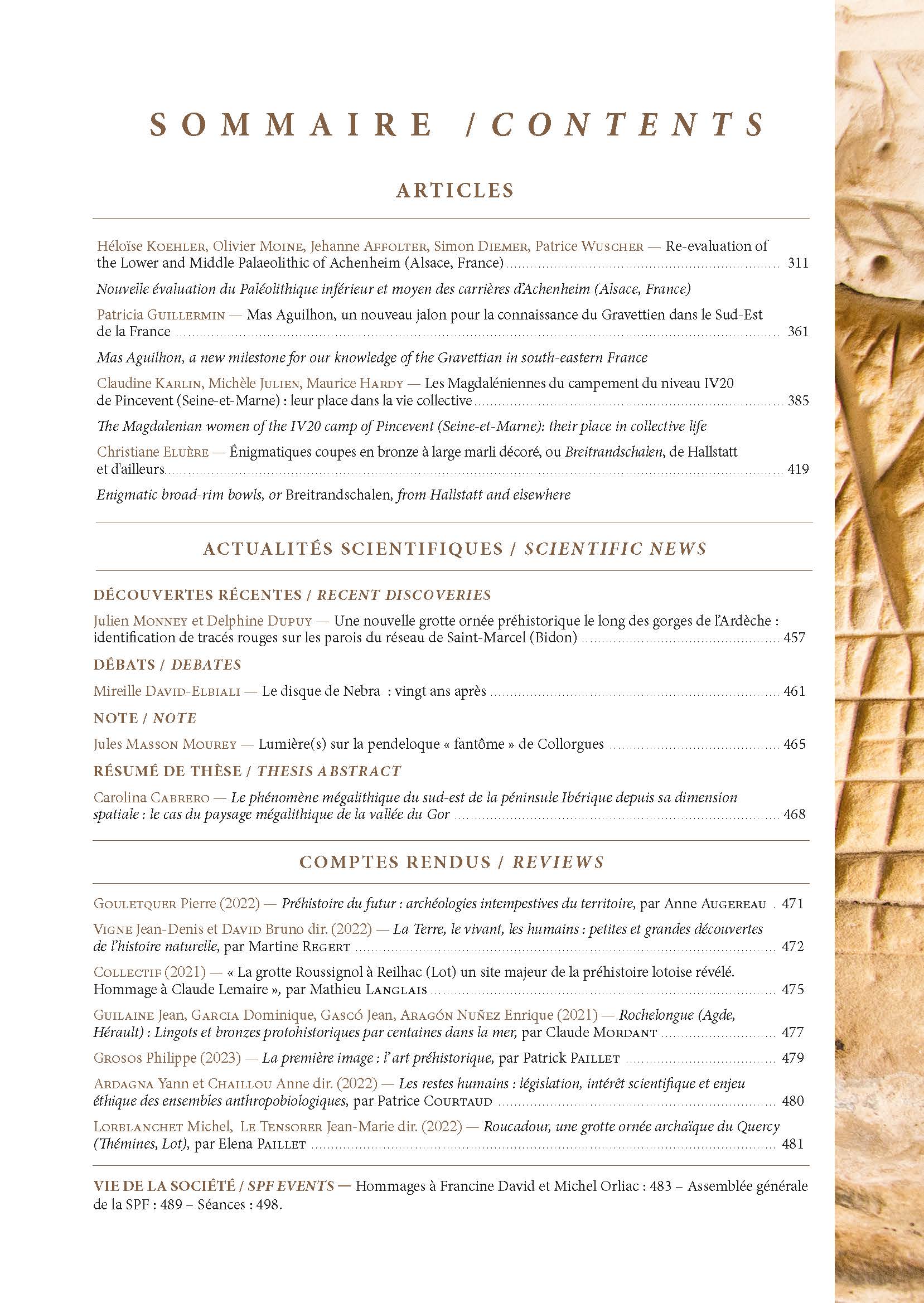
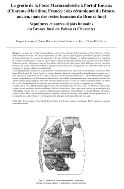
03-2023, tome 120, 1, p. 49-62 - Gachina J., Boulestin B., Gomez de Soto J., Trézéguet C. (2023) La grotte de la Fosse Marmandrèche à Port-dEnvaux (Charente-Maritime, France) : des céramiques du Bronze ancien, mais des restes humains du Bronze final. S
La grotte de la Fosse Marmandrèche à Port-d'Envaux (Charente-Maritime, France) : des céramiques du Bronze ancien, mais des restes humains du Bronze final Sépultures et autres dépôts humains du Bronze final en Poitou et Charentes
Jacques Gachina, Bruno Boulestin, José Gomez de Soto, Céline Trézéguet
Résumé : La grotte de la Fosse Marmandrèche s'ouvre sur le territoire de la commune de Port-d'Envaux, en Charente-Maritime. C'est au cours de son exploration, en 1983, que des spéléologues y recueillirent quelques ossements animaux et humains, des tessons de céramique et de rares artefacts lithiques. Le mobilier céramique, très fragmenté et constitué uniquement de récipients à paroi épaisse, paraît globalement cohérent avec une série homogène datable du Bronze ancien saintongeais, sans que l'on puisse exclure qu???une partie puisse dater du Bronze moyen. Les restes humains, par contre, sont datés du Bronze final par le radiocarbone. Ils se rapportent à au moins deux individus, un adolescent et un sujet adulte ou de taille adulte.
L'assemblage humain de la Fosse Marmandrèche est actuellement le seul attesté pour le Bronze final en cavité en Saintonge. Dans le reste du Centre-Ouest, les vestiges humains datant de cette période sont également peu nombreux, et dans leur grande majorité ils ont été ramassés dans des cavités karstiques charentaises. Leur attribution chronologique repose essentiellement sur des datations radiocarbone, du mobilier contemporain leur étant rarement associé. Ces dépôts humains pourraient pour partie être de nature funéraire, mais le statut de certains demeure ambigu. En dehors des cavités, les sépultures du Bronze final sont rares en Centre-Ouest, qui ne sont connues que sur trois sites.
La grotte de la Fosse Marmandrèche apporte donc une documentation nouvelle à la fois sur le Bronze ancien saintongeais et sur les dépôts humains du Bronze final en Centre-Ouest, deux sujets dont nous ne savons presque rien. Elle rappelle en outre que les associations chronologiques apparentes entre mobiliers et vestiges humains ne sont pas toujours réelles. Elle donne enfin l'occasion de souligner l'intérêt des datations radiocarbone des vestiges humains, à la fois pour la raison précédente et pour documenter les pratiques mortuaires et leur chronologie.
Mots-clés : Bronze ancien, Bronze final, Centre-Ouest de la France, pratiques mortuaires, dépôts humains en cavités, dates radiocarbone.
Abstract: The cave of the Fosse Marmandrèche is located near the village of Port-d'Envaux, in the French department of Charente-Maritime. This small cave about forty metres wide, is only accessible today through an opening in the roof and is largely filled in with fallen rocks. Upon its exploration in 1983, speleologists collected animal and human bones, ceramic sherds and rare lithic artefacts.
The very fragmented ceramic material consists only of thick-walled vessels. The forms that can be identified correspond to barrel-shaped vases, a vase with a conical upper part, another with a constricted opening and subvertical neck, and a jar. The decorations identified are mainly digital impressions, pustules, cords, cord impressions and pellet decoration. Vases decorated with pellets appear in Central West France in Beaker contexts and become more numerous from the Early Bronze Age. In inland Central West France, they disappear during the Middle Bronze Age with the development of the Duffaits culture, but they persist at this time in the maritime zone, as well as in Aquitaine, where they are also attested from the Early Bronze Age. In the Central West France maritime area, the barrel-shaped vases can also be attributed to the Early or Middle Bronze Age, as can digital decorations and cords arranged in a net pattern. On the other hand, the cord-impressed sherds and the vase with a closed orifice, probably a biconical vessel, are characteristic of the Early Bronze Age. Finally, the ceramic material as a whole is coherent with a homogeneous series that can be dated to the regional Early Bronze Age. Nevertheless, this homogeneity is only conjectural, as some of the ceramics may also date to the Middle Bronze Age.
The human remains, numbering a little under thirty, are from a minimum of two individuals: an adolescent aged 15 to 20 years and an adult or adult-sized individual. The results of the radiocarbon dating of two bone fragments date the remains to the Late Bronze Age. The significant difference in the two dates points to the successive deposits of a collective burial, if these deposits are in fact funerary, which, given the data at our disposal, is not entirely clear.
The human assemblage of the Fosse Marmandrèche is currently the only one attested for the Late Bronze Age in caves in Saintonge, where burials from this period are only known at the Borderie site, at Saint-Pierre-d'Oléron. In the rest of Central West France, deposits of human remains dating from the Late Bronze Age are also rare, and for the most part very poorly known, being only documented by speleological discoveries or collectings made during surveys in the karstic cavities of the Charente department. In these cases, human remains seem rarely associated with contemporary material, the only apparent exceptions being the La Tour cave at Vouthon and the Licorne cave at La Rochefoucauld-en-Angoumois, discovered in 2021. The chronological attribution of these remains is therefore largely based on radiocarbon analyses, with all the dates obtained covering the entire Late Bronze Age. Funerary deposits in the karst cavities of Central West France are known from the Middle Neolithic, well documented for the Early and Middle Bronze Age, and still attested in the Hallstatt D and La Tène A periods. Thus, some of the Late Bronze Age deposits could also be funerary in nature, expressing a continuity in traditional regional practices. However, it is uncertain whether all the human deposits in underground environments belong to the funerary sphere, the status of those found in karstic wells in Charente, at the Four du Diable in Bunzac and at Aven Victor in Torsac, or of the isolated skull in the Rancogne cave, being particularly ambiguous. Except for those found in caves, human assemblages from the Late Bronze Age are very rare in Central West France. In addition to the burials from Saint-Pierre-d'Oléron, only two inhumations are known at La Viaube 1 in Jaunay-Clan, in the Vienne department, and a cremation at Luxé, in the Charente department. It should also be remembered that the ditched enclosures, too systematically presented as funerary structures and which in some cases date back to the Late Bronze Age, have not yielded any human remains from this period.
In fact, the contribution of the Fosse Marmandrèche cave is three-fold. Firstly, it has provided a collection of ceramics attributable to the Early Bonze Age, a period about which we know practically nothing for the Saintonge area. Secondly, it offers the only human assemblage in an underground environment from the Late Bronze Age in this same region, human deposits dating from this phase of the Bronze Age being extremely rare in the entire Central West France. Finally, the Fosse Marmandrèche provides an opportunity to recall that human remains and material discovered in close proximity to each other and which may at first sight appear to be chronologically associated are not necessarily contemporary. This is particularly true for finds in caves, but it is also true for open-air sites. This highlights the importance of the radiocarbon dating of human remains, both for the above reason and to document mortuary practices and their chronology.
Keywords: Early Bronze Age, Late Bronze Age, Central West France, mortuary practices, human deposits in caves, radiocarbon dates.
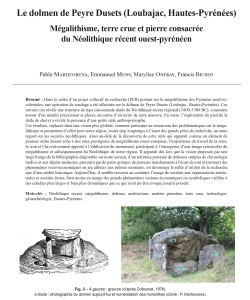
02-2023, tome 120, 1, p. 29-47 - Marticorena P., Mens E., Onfray M., Bichot F. (2023) Le dolmen de Peyre Dusets (Loubajac, Hautes-Pyrénées) : mégalithisme, terre crue et pierre consacrée du Néolithique récent ouest-pyrénéen
Le dolmen de Peyre Dusets (Loubajac, Hautes-Pyrénées) Mégalithisme, terre crue et pierre consacrée du Néolithique récent ouest-pyrénéen
Pablo Marticorena, Emmanuel Mens, Marylise Onfray, Francis Bichot
Résumé : Dans le cadre d'un projet collectif de recherche (PCR) portant sur le mégalithisme des Pyrénées nord-occidentales, une opération de sondage a été effectuée sur le dolmen de Peyre Dusets (Loubajac, Hautes-Pyrénées). Ces travaux ont révélé une structure de type caussenarde datée du Néolithique récent régional (3 800-3 300 BC), construite autour d'un menhir préexistant et placée au centre d'un tertre de terre massive. En outre, l'exploration du pied de la dalle de chevet a révélé la présence d'une petite stèle anthropomorphe.
Ces résultats, replacés dans une vision plus globale, viennent participer au renouveau des problématiques sur le mégalithisme et permettent d???offrir pour notre région, restée trop longtemps à l'écart des grands pôles de recherche, un autre regard sur les sociétés néolithiques. Ainsi au-delà de la découverte de cette stèle qui apparaît comme un élément de premier ordre faisant écho à des sites prestigieux du mégalithisme ouest-européen, l???importance du travail de la terre, le soin et l'investissement apporté à l'édification du monument, participent à l'émergence d'une image renouvelée du mégalithisme et subséquemment du Néolithique de notre région. Il apparaît dès lors que la vision proposée par une large frange de la bibliographie disponible sur notre secteur, d'un territoire parsemé de dolmens simples de chronologie tardive et aux dépôts modestes, parcouru par de petits groupes de pasteurs transhumants à l'écart de tout et (surtout) des phénomènes socio-économiques en jeu ailleurs aux mêmes moments, est davantage le reflet d'un état de la recherche que d'une réalité historique. Aujourd'hui, il semble ressortir au contraire l'image de sociétés aux organisations territoriales et sociales fortes, bien moins en marge des grands phénomènes sociaux-économiques ou symboliques visibles à des échelles plus larges et bien plus dynamiques que ce qui avait pu être évoqué jusqu'à présent.
Mots-clés : Néolithique récent, mégalithisme, dolmen, architecture, matière première, terre crue, technologie, géoarchéologie, Hautes-Pyrénées.
Abstract: The North-Western Pyrenees offers a remarkable archaeological potential for the Neolithic period in a geographical key sector of Western Europe, between the Atlantic Ocean and the Pyrenees, with natural passages to the Iberian Peninsula. However, the region has been excluded from major research with a noted absence from national overviews.
In 2015, we developed a Collective Research Project (PCR) on the theme of Considering megalithism as a gateway, with the aim to improve our understanding of regional megalithism, its forms, its symbolism and its chronology, through multi-method and multi-scalar approaches and the Neolithic and recent Prehistory of the north-western Pyrenees. Our study focused on the emergence of megalithic building and its development on a more global scale.
Known as Pierre d'Uzès, the dolmen of Peyre Dusets is mentioned on the cadastral maps of Lourdes (1812) and Loubajac (1813) as a boundary marker between the two municipalities. E. Dufourcet describes the first excavation and a survey in a paper published in 1876. The dolmen is mentioned subsequently, but no other excavations seemed to have taken place.
The first study of the monument mentions a megalithic chamber composed of four monoliths including a cover slab and three orthostats, one of them can be interpreted as the chevet stone, facing the East. The four slabs are all of "Cauterets" granite, probably of the same origin from the Mindel moraine that outcrops to the south of the site. The architectural and geological studies, as well as a geophysical survey of the monument (electrical map and tomography) raises questions as to the chamber's architecture, its position and the composition of the tumulus. A survey in 2019 aimed to answer these questions. Our work used an ???evaluation??? type approach that is minimally invasive and adapted to our research. We have made three surveys on the Peyre Dusets site.
We were not able to document the sepulchral levels, due to the excavation. We did however survey the inside of the chamber that seems to have been slightly over-deepened, forming an elongated hollow in the direction of the length of the chamber. The excavation also provided details on how the monoliths were put into place, by demonstrating that blocks no 2 and no 3 were put in first. The orthostat simply stands on the local clay substrate, while the bedside slab is wedged in a pit dug into the clay. The pit has a double-layered filling. The lower part is made up of a dense array of different rocks (schist, granite and sandstone) almost exclusively yellow kneaded clay. The upper layer contains balls of yellow and white clay clearly visible during excavation with an average diameter of 8 to 10 cm and a few scattered stones.
The radiocarbon dating places the monument's construction in the recent Neolithic period (4735 ± 30 BP) and several clues suggest that the bedside slab was first a menhir erected before the building of the dolmen. The date is consistent with the known data for this type of monument in the area.
A shale slab with a particular shape was discovered during the excavation of the chevet stone wedging pit. The slab's form and the context of its discovery suggest that it is an anthropomorphic stele.
The excavation of the tumulus revealed an earthen feature preserved to a height of nearly 1.80 m and built using the massive dirt technique. The preparation of the ground, the implementation of a foundation layer and the finely prepared character of the materials are all indicators of the investment made in the building of the monument.
These results, placed in a more global setting renew research into megalithism in our region giving it its rightful place as a major reference for Neolithic studies.
Beyond the discovery of the stele that mirrors the prestigious megalithic sites of Western European, the importance of the mound, the care and the investment brought to the building of the monument, renew our knowledge of megaliths and of the Neolithic in our region. Until recently, the vision shared and transcribed in archaeological literature, reflected more a history of the research carried out in the area than a historical reality. It depicted a landscape dotted with simple dolmens, walked by shepherds in small transhumant groups, away from everything and (especially) from the socio-economic phenomena that were playing out elsewhere at the time. Recent work on West Pyrenean megaliths, whether it falls within the framework of our research project that focuses on the dolmen of Peyre Dusets, or within the framework of preventive excavations as on the site of the CM10 in Lannemezan, offer a vision quite far from this "image d'Épinal". They all show that the building of monuments in the area happened within strong technical and symbolic systems that led to major changes in the landscape, these dynamics being completely synchronous with those in play in the rest of Western Europe.
Keywords: Late Neolithic, Megalithism, dolmen, architecture, raw material, earthen construction, technology, geoarchaoeology.
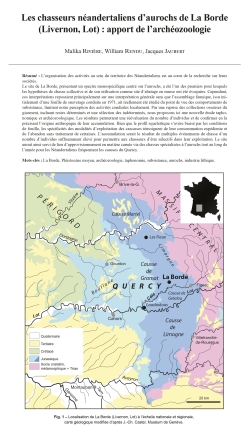
01-2023, tome 120, 1, p. 7-27 - Malika RIVIERE, William RENDU, Jacques JAUBERT - Les chasseurs néandertaliens daurochs de La Borde (Livernon, Lot) : apport de larchéozoologie
Les chasseurs néandertaliens d'aurochs de La Borde (Livernon, Lot) : apport de l'archéozoologie
Malika Rivière, William Rendu, Jacques Jaubert
Résumé : L'organisation des activités au sein du territoire des Néandertaliens est au cour de la recherche sur leurs sociétés. Le site de La Borde, présentant un spectre monospécifique centré sur l'aurochs, a été l'un des premiers pour lesquels les hypothèses de chasse collective et de son utilisation comme site d'abatage en masse ont été évoquées. Cependant, ces interprétations reposaient principalement sur une interprétation générale sans que l'assemblage faunique, issu initialement d'une fouille de sauvetage conduite en 1971, ait réellement été étudié du point de vue des comportements de subsistance, limitant notre perception des activités conduites localement. Par une reprise des collections osseuses du gisement, incluant restes déterminés et une sélection des indéterminés, nous proposons ici une nouvelle étude taphonomique et archéozoologique. Les résultats permettent une réévaluation du nombre d'individus et de confirmer en la précisant l'origine anthropique de leur accumulation. Bien que le profil squelettique s'avère biaisé par les conditions de fouille, les spécificités des modalités d'exploitation des carcasses témoignent de leur consommation expédiente et de l'abandon sans traitement de certaines. L'accumulation serait le résultat de multiples évènements de chasse d'un nombre d'individus suffisamment élevé pour permettre aux chasseurs d'être sélectifs dans leur exploitation. Le site aurait ainsi servi de lieu d'approvisionnement en matière carnée via des chasses spécialisées à l'aurochs tout au long de l'année pour les Néandertaliens fréquentant les causses du Quercy.
Mots-clés : La Borde, Pléistocène moyen, archéozoologie, taphonomie, subsistance, aurochs, industrie lithique.
Abstract: Recent research on Neanderthal subsistence strategies in southwestern Europe identify the development, at the end of the Middle Paleolithic, of task specific locations dedicated to the capture of a large number of prey (Delagnes et Rendu, 2011). One of the main characteristics of these sites is their monospecific faunal spectrum centered on large mammals. However, it has been proposed that these task specific locations evidence the emergence of specialized hunting (Costamagno et al., 2006) at the end of the Mousterian era (starting during MIS4). Earlier specialized faunal spectra have been identified in the region (Jaubert et al., 2005 ; Discamps et al., 2011; Discamps et Royer, 2017) and the question of the development of such hunting specialization in earlier periods of the Middle Paleolithic can be raised.In this context, the site of La Borde (Livernon, France) is of prime interest to discuss the development of specific hunting strategies by Neanderthal populations. Localized in the Quercy and excavated by M. Lorblanchet in the 70???s, La Borde is a skinhole, which yielded a large faunal assemblage almost exclusively composed of aurochs remains associated with a denticulate Mousterian (Jaubert et al., 1990). The carcass accumulation was interpreted as resulting from communal hunting conducted by Neanderthal on the large bovine (Jaubert and Brugal, 1990). However, very limited zooarchaeological data were available, limiting our perception of the hunting strategies developed by the Neanderthals. Thus, we propose here a reevaluation of the site based on a combine taphonomic and zooarchaeological approach. The study was realized in two steps: firstly, the collection of La Borde stored at PACEA (CNRS ??? Bordeaux University) was analyzed in the framework of a Master 2 thesis (Rivière, 2018). This collection was constituted of identified bones selected by Slott-Moller (1990) for his paleontological analysis. A selection of the Cabrerets collection, which includes the faunal remains considered as unidentifiable, was included to the analysis in order to precise the faunal spectrum and to correct the MNI. During our study, 5770 bones remains and 497 teeth were analyzed. The aurochs largely dominates the faunal spectrum (with a % NISP of 95 %), which is characterized by a high rate of identification (28 %) due to the over-representation of large remains, a direct consequence of the excavation strategies. New species were identified in our revision with the discovery of a hyena canine and five remains of bear. Based on the faunal spectrum and its association with the denticulate Mousterian (Jaubert, 1990), an attribution of the site to the MIS7 is proposed. The absence of digested bones, the scarcity of carnivores and the absence of their young individuals conducted to reject these agents for the origin of the bone accumulation. On the opposite, the human modifications on the material associated with the large number of silex, sustain the hypothesis of a human accumulation. The taphonomic analysis of the material confirms the important alteration of the cortical surface of the bone mainly due to the weathering and some calcite depositions. However, these modifications seem to have only a limited impact on the representation of the human modifications and cannot explain their relative scarcity. The reexamination of the aurochs bone assemblage leads to a large increase of the previously proposed MNI to now 63 individuals (based on the second upper molar). The skeletal profile has been largely biased during the rescue excavation and no significant correlation were identified between the frequency of the anatomical parts and their density or their nutritive utility (tested by the FUI and the MUI). The skull and the belts are over-represented compared to the long bones. The phalanges are found complete with no evidence of human intervention. The limited human impact (8,1 % of the remains of the Bordeaux collection) is characterized by cut marks, notches and retouchers. Disarticulation and filleting are attested but bone fragmentation for recovery of the marrow and grease was limited. It results from it a limited number of green fractures (observable on only 54 % of the remains) and the prevalence of long bone articular extremities attests that they were not exploited for the extraction of grease. Simultaneously, the phalanges are found complete with no evidence of human intervention. All these elements suggest a limited investment of the butchery activities. The seasonal indication obtained by Slott-Moller (1990) based on tooth eruption sequence indicate multiple periods of death around the year. Based on our results and by taking into account the age profile established by Brugal (1995), we conclude that the accumulation is the consequence of multiple events of mass slaughtering of aurochs resulting from a specialized hunting on this animal. The site would have been secondarily scavenged by carnivores. Thus, our study brings some quantify data confirming the first interpretation of the site made by Jaubert and colleagues (1990), but simultaneously it adds some nuances. The hunters of La Borde aurochs took advantage of the topography of the landscape to bring down and trap the animals, and then processed the carcasses to obtain the resources they needed. The limited human impact on the carcasses supports the hypothesis of their large number and a quantity of food to process larger than what the group needed or was able to transport. The presence of all skeletal elements but in imbalance proportion and the low rate of butchery marks could correspond to one of the following exploitation modalities: 1) either the carcasses were only slightly or not at all invested, the first individuals that fell in the trap being neglected because they were buried under their fellow animals, or 2) some animals may have been the object of a more selective exploitation. The site was probably used recurrently during the year (Slott-Moller, 1990), and no evidence of differed consumption have been identified. Thus, the question of a residential mobility may be here raised. The topography characteristic of the site and the possible presence of aurochs in large number all along the year is probably the reasons why humans decided to invest this specific location, finding there the assurance to have always at their disposition a large resource of food. The conclusion of our study highlights the originality of La Borde in the Middle Paleolithic record of Western Europe with a monospecific faunal spectrum resulting in the slaughter of a large number of aurochs at least 130 ky ago. This study helps to document the diversity of the subsistence strategies developed by Neanderthal during the Pleistocene.
Keywords: La Borde, Middle Pleistocene, zooarchaeology, taphonomy, subsistance, aurochs, lithic industry.
Coordonnées
Pôle éditorial de la MSH Mondes
(Maison de l'archéologie et de l'éthnologie)
Boite 41
21 allée de l'Université
F-92023 Nanterre cedex - FRANCE